IMAGES TAKEN NEAR TO
Haddonfield, LONDON, SE8 5AT
Introduction
This page details the photographs taken nearby to Haddonfield, SE8 5AT by members of the Geograph project.
The Geograph project started in 2005 with the aim of publishing, organising and preserving representative images for every square kilometre of Great Britain, Ireland and the Isle of Man.

There are currently over 7.5m images from over14,400 individuals and you can help contribute to the project by visiting https://www.geograph.org.uk
Image Map
Images are licensed for reuse under creativecommons.org/licenses/by-sa/2.0
Notes
- Clicking on the map will re-center to the selected point.
- The higher the marker number, the further away the image location is from the centre of the postcode.
Image Listing (206 Images Found)
Images are licensed for reuse under creativecommons.org/licenses/by-sa/2.0
Image
Details
Distance
1
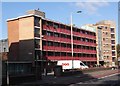
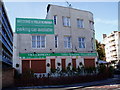
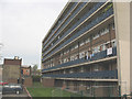
Haddonfield Estate, Bush Road, Rotherhithe, London SE16
Built in the late 1950s on the site of dwellings and a school that had been destroyed in WWII. Consists of two buildings; the one shown is John Brent House, which is believed to be named after a Rotherhithe shipbuilder. To its right can be seen the side of Albert Starr House, named after Councillor A. Starr JP, a former Mayor of Bermondsey.
Image: © Chris Lordan
Taken: 12 Oct 2009
0.01 miles
2
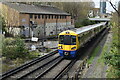
Southbound Overground train on the former East London Line
Image: © David Martin
Taken: 10 Apr 2022
0.05 miles
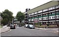
3
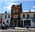
The Farriers Arms
A traditional Irish pub on Lower Road.
Image: © JThomas
Taken: 20 Jun 2022
0.05 miles
5
Old Manor House (ex) 58, Bush Road, Rotherhithe, London, SE16
Stands opposite Bestwood Street and that's all I know about the building.
Image: © Chris Lordan
Taken: 30 Oct 2007
0.05 miles
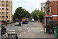
6
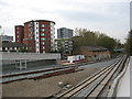
New track layout at Deptford Road Junction
The junction was where the former line to Peckham met the line from New Cross on the former East London Line. The Peckham tracks were lifted as early as 1913 though one track to the west side of New Cross Gate survived until 1964 [source: London Railway Atlas by Joe Brown]. As part of the redevelopment of the route for London Overground, a stub of track was laid (left foreground) to permit the Peckham route to be reinstated at a later date. The track at the far side of the formation is the northbound track from New Cross Gate that now uses a new flyover - see Image Behind it is a ramp to the new footbridge.
Image: © Stephen Craven
Taken: 27 Apr 2010
0.05 miles
7
Woodman public house (site of)
Site of Woodman public house, a map dated 1868 showed it on the north side of Rotherhithe New Road close to the junction with Lower Road. Above is 'today's' view.
Image: © Chris Lordan
Taken: 24 Jul 2011
0.06 miles
8
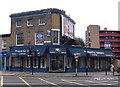
Red Lion pub (ex) 198, Lower Road, Rotherhithe, London,SE16
At the junction with Rotherhithe New Road. First recorded in 1805 and ceased trading in 1994. This is the second building; the first was facing west to 'catch' travellers on the busy Rotherhithe New Road. The one shown, built 1870, is facing north to 'catch' travellers on the busier Deptford Lower Road. About 1910 there was a very large red lion, on the roof above the white corner window, that was facing Plough Way. The clean bricks above the same window carried a large sign. The advertising board is hiding four windows. Previous names include 'Halfway House' : The Ship Marlborough' and the 'Jolly Miller'.
Image: © Chris Lordan
Taken: 19 Oct 2009
0.06 miles
9
Housing on Trundleys Terrace (2)
A medium-rise housing block on the north side of Trundleys Terrace, seen from the ramp to the nearby railway footbridge. See also Image
Image: © Stephen Craven
Taken: 27 Apr 2010
0.07 miles
10
St Helena Road (part), Rotherhithe, London, SE16
Did at one time extend to Silwood Street. It was about this location in the early 1700's where the famous St Helena Tea Gardens stood. It was built on the periphery of the events concerning the Mill Pond and described as a general purpose entertainment area. It comprised of two fish ponds with yew trees forming alcoves, two Chinese pavilions surrounded by weeping willows and similar. Nearby was the parade ground where the Rotherhithe Volunteers trained.
Image: © Chris Lordan
Taken: 23 Sep 2009
0.07 miles