IMAGES TAKEN NEAR TO
Admiral Street, LONDON, SE8 4HY
Introduction
This page details the photographs taken nearby to Admiral Street, SE8 4HY by members of the Geograph project.
The Geograph project started in 2005 with the aim of publishing, organising and preserving representative images for every square kilometre of Great Britain, Ireland and the Isle of Man.

There are currently over 7.5m images from over14,400 individuals and you can help contribute to the project by visiting https://www.geograph.org.uk
Image Map (Loading...)


Getting Data...Please wait
Leaflet Map data © OpenStreetMap
Images are licensed for reuse under creativecommons.org/licenses/by-sa/2.0
Notes
- Clicking on the map will re-center to the selected point.
- The higher the marker number, the further away the image location is from the centre of the postcode.
Image Listing (189 Images Found)
Images are licensed for reuse under creativecommons.org/licenses/by-sa/2.0
Image
Details
Distance
1
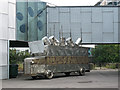
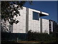
I accuse the oil companies...
When I first saw the slogan on the side of this splendid mock armoured vehicle in the grounds of the Stephen Lawrence centre I thought it had been prepared for 'climate change' protests, but then I saw the name Ken Saro-Wiwa on the front http://en.wikipedia.org/wiki/Ken_Saro-Wiwa and realised it was making a more locally political statement, given the large Nigerian community in this part of London.
Image: © Stephen Craven
Taken: 19 Sep 2009
0.03 miles
2
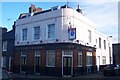
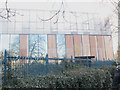
Crown and Sceptre Public House (closed)
On the junction of Friendly Street (in front) and Cranbrook Road (on the right).
Image: © David Anstiss
Taken: 27 Nov 2009
0.04 miles
6
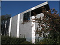
The Stephen Lawrence Centre damaged
This college Image hit the national news when it was vandalised in an alleged racist attack on 14 February 2008 shortly after its official opening.
Image: © Stephen Craven
Taken: 16 Feb 2008
0.06 miles
7
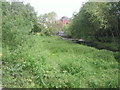
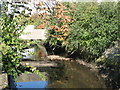
Brookmill Park
The River Ravensbourne used to run in a concrete channel through Brookmill Park but as part of the construction of the Lewisham extension of the Docklands Light Railway in 1999, the river was given a more 'natural' winding course,whilst the DLR used the old course of the river. It was an inspired solution and both the park and the DLR benefited. Brookmill Park has been expanded over the years although some of the park was lost with the DLR extension.
Image: © Marathon
Taken: 6 May 2011
0.06 miles
8
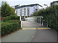
Cycle bridge near Brookmill Road
The bridge carries National Cycle Route 21 and a footpath across the Ravensbourne river between Brookmill Park and Deptford Bridge.
Image: © Stephen Craven
Taken: 19 Sep 2009
0.06 miles
9
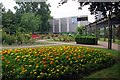
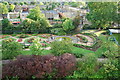
Flowerbed in Brookmill Park
A welcome splash of colour in an urban environment
Image: © Glyn Baker
Taken: 19 Jul 2017
0.06 miles