IMAGES TAKEN NEAR TO
Albyn Road, LONDON, SE8 4EB
Introduction
This page details the photographs taken nearby to Albyn Road, SE8 4EB by members of the Geograph project.
The Geograph project started in 2005 with the aim of publishing, organising and preserving representative images for every square kilometre of Great Britain, Ireland and the Isle of Man.

There are currently over 7.5m images from over14,400 individuals and you can help contribute to the project by visiting https://www.geograph.org.uk
Image Map
Images are licensed for reuse under creativecommons.org/licenses/by-sa/2.0
Notes
- Clicking on the map will re-center to the selected point.
- The higher the marker number, the further away the image location is from the centre of the postcode.
Image Listing (183 Images Found)
Images are licensed for reuse under creativecommons.org/licenses/by-sa/2.0
Image
Details
Distance
3
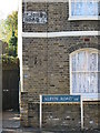
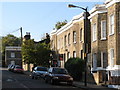
Sign for Albyn Road, SE8 - formerly St. John's Road
Image: © Mike Quinn
Taken: 28 Oct 2008
0.05 miles
5
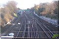
Railway line to St. John's Station
Seen from Friendly Street bridge (No. XTD 108). Line leads from New Cross Station.
Image: © David Anstiss
Taken: 27 Nov 2009
0.06 miles
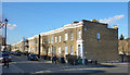
7
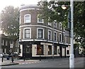
The Cranbrook, Public House, St.Johns
As seen from Ravensbourne Park.
On the junction of Cranbrook Road (on the left) and Brookmill Road (on the right).
Strangely no names or signs, had to find name from the web.
Image: © David Anstiss
Taken: 25 Sep 2011
0.08 miles
8
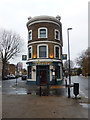
The Brookmill, St Johns
This pub squeezes in between Brookmill Road (to the right) and Cranbrook Road (to the left), and is part of the Brookmill Road conservation area. Compare with this picture taken about seven years earlier when the establishment (then called the Cranbrook) looked very run down: Image . It was refurbished in a contemporary style and reopened in 2016.
Image: © Stephen McKay
Taken: 1 Dec 2018
0.08 miles
10
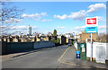
Outside St Johns Station
St Johns Vale is the road here, which heads down a gentle slope towards the Ravensbourne river.
Image: © Des Blenkinsopp
Taken: 6 Mar 2020
0.09 miles