IMAGES TAKEN NEAR TO
Czar Street, LONDON, SE8 3JN
Introduction
This page details the photographs taken nearby to Czar Street, SE8 3JN by members of the Geograph project.
The Geograph project started in 2005 with the aim of publishing, organising and preserving representative images for every square kilometre of Great Britain, Ireland and the Isle of Man.

There are currently over 7.5m images from over14,400 individuals and you can help contribute to the project by visiting https://www.geograph.org.uk
Image Map
Images are licensed for reuse under creativecommons.org/licenses/by-sa/2.0
Notes
- Clicking on the map will re-center to the selected point.
- The higher the marker number, the further away the image location is from the centre of the postcode.
Image Listing (326 Images Found)
Images are licensed for reuse under creativecommons.org/licenses/by-sa/2.0
Image
Details
Distance
1
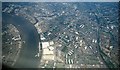
Deptford & The Thames from the air, 2001
Prominent below are the pale buildings at Convoys Wharf, several of them now demolished. On the left is the Greenwich Reach of the Thames, with the Royal Naval College at top left.
Image: © Derek Harper
Taken: 1 Jun 2001
0.04 miles

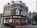
3
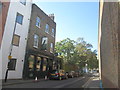
The Dog and Bell public house, Deptford
Image: © John Slater
Taken: 11 Oct 2016
0.05 miles
4
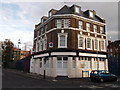
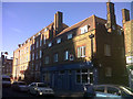
Former Kings Arms, Deptford
Converted pub on the junction of Prince Street (on the left) and New King Street (on the right). Now converted into flats.
See Image, when just a closed pub.
Image: © David Anstiss
Taken: 25 Sep 2011
0.06 miles
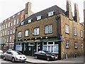
6
Former Osborne Arms, New King Street, Deptford
This building is a former pub, now ironically the base of Bench Outreach, a Christian project helping people overcome alcohol and drug addiction.
Image: © Stephen Craven
Taken: 3 Jul 2014
0.06 miles
8
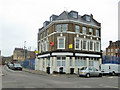
Former Army and Navy pub, SE8
On the corner of Prince Street and New King Street.
Image: © Robin Webster
Taken: 6 Apr 2019
0.06 miles
9
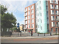
Link path to Clyde Street
The block at the right is the Drake building Image What used to be a narrow passage at this point between Evelyn Street (foreground) and Clyde Street beyond has been widened as part of the development, and signed as a shared use pedestrian/cycle path.
Image: © Stephen Craven
Taken: 4 Sep 2009
0.06 miles
10

Deptford: former "Navy Arms" public house
Converted to residential use.
Image: © Jim Osley
Taken: 17 Feb 2019
0.06 miles