IMAGES TAKEN NEAR TO
Dryfield Walk, LONDON, SE8 3JJ
Introduction
This page details the photographs taken nearby to Dryfield Walk, SE8 3JJ by members of the Geograph project.
The Geograph project started in 2005 with the aim of publishing, organising and preserving representative images for every square kilometre of Great Britain, Ireland and the Isle of Man.

There are currently over 7.5m images from over14,400 individuals and you can help contribute to the project by visiting https://www.geograph.org.uk
Image Map
Images are licensed for reuse under creativecommons.org/licenses/by-sa/2.0
Notes
- Clicking on the map will re-center to the selected point.
- The higher the marker number, the further away the image location is from the centre of the postcode.
Image Listing (296 Images Found)
Images are licensed for reuse under creativecommons.org/licenses/by-sa/2.0
Image
Details
Distance
1
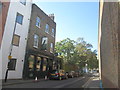
The Dog and Bell public house, Deptford
Image: © John Slater
Taken: 11 Oct 2016
0.01 miles
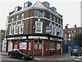
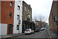
3
Former Army and Navy pub, SE8
On the corner of Prince Street and New King Street.
Image: © Robin Webster
Taken: 6 Apr 2019
0.03 miles
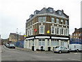
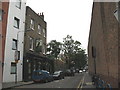
4
Former Kings Arms, Deptford
Converted pub on the junction of Prince Street (on the left) and New King Street (on the right). Now converted into flats.
See Image, when just a closed pub.
Image: © David Anstiss
Taken: 25 Sep 2011
0.03 miles
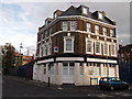
5

Deptford: former "Navy Arms" public house
Converted to residential use.
Image: © Jim Osley
Taken: 17 Feb 2019
0.03 miles
6
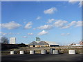
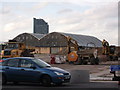
Convoys Wharf, Deptford
This is the former site of the Royal Dockyard and is about to be redeveloped.
Image: © Chris Whippet
Taken: 16 Feb 2014
0.03 miles
8
The Dog and Bell
Deptford's best-kept secret: voted "CAMRA London pub of the year" not long ago and Casque Mark rated, this friendly local on Prince Street is often surprisingly quiet on weekdays. They have their own bike racks, too (at the right of the photo) for the many cyclists who call in. According to the landlady, until c.1900 the pub was called the Royal Marine. The origin of the present name may lie in the original name of the street (Dog Street) or else after the practice of duck-baiting.
Image: © Stephen Craven
Taken: 18 Aug 2008
0.05 miles
9
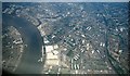
Deptford & The Thames from the air, 2001
Prominent below are the pale buildings at Convoys Wharf, several of them now demolished. On the left is the Greenwich Reach of the Thames, with the Royal Naval College at top left.
Image: © Derek Harper
Taken: 1 Jun 2001
0.05 miles
10
Olympia Convoy's Wharf, Deptford
Grade II listed Warehouse in the former Deptford Royal Dockyard.
The area around the former warehouse was meant to be re-developed, but still in planning.
In the background is Image, on Deptford Strand.
See http://www.britishlistedbuildings.co.uk/en-397451-olympia-convoy-s-wharf-deptford for more details about the listed building.
Image: © David Anstiss
Taken: 25 Sep 2011
0.06 miles