IMAGES TAKEN NEAR TO
Benbow Street, LONDON, SE8 3HD
Introduction
This page details the photographs taken nearby to Benbow Street, SE8 3HD by members of the Geograph project.
The Geograph project started in 2005 with the aim of publishing, organising and preserving representative images for every square kilometre of Great Britain, Ireland and the Isle of Man.

There are currently over 7.5m images from over14,400 individuals and you can help contribute to the project by visiting https://www.geograph.org.uk
Image Map
Images are licensed for reuse under creativecommons.org/licenses/by-sa/2.0
Notes
- Clicking on the map will re-center to the selected point.
- The higher the marker number, the further away the image location is from the centre of the postcode.
Image Listing (357 Images Found)
Images are licensed for reuse under creativecommons.org/licenses/by-sa/2.0
Image
Details
Distance
9
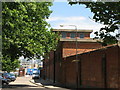
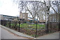
Electricity sub-station building, Deptford Green, SE8
Image: © Mike Quinn
Taken: 1 Jul 2009
0.07 miles
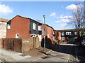
10
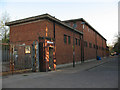
Electricity building, Deptford Green
This building (also seen from the opposite direction in Image ) is one of the few remaining buildings from the former Ferranti power station in Deptford (1899-1992).
Image: © Stephen Craven
Taken: 8 Apr 2011
0.07 miles