IMAGES TAKEN NEAR TO
Millard Road, LONDON, SE8 3GB
Introduction
This page details the photographs taken nearby to Millard Road, SE8 3GB by members of the Geograph project.
The Geograph project started in 2005 with the aim of publishing, organising and preserving representative images for every square kilometre of Great Britain, Ireland and the Isle of Man.

There are currently over 7.5m images from over14,400 individuals and you can help contribute to the project by visiting https://www.geograph.org.uk
Image Map
Images are licensed for reuse under creativecommons.org/licenses/by-sa/2.0
Notes
- Clicking on the map will re-center to the selected point.
- The higher the marker number, the further away the image location is from the centre of the postcode.
Image Listing (161 Images Found)
Images are licensed for reuse under creativecommons.org/licenses/by-sa/2.0
Image
Details
Distance
1
Steps to Millard Road
Steps down from the playground by the riverside Image to Millard Road; the path then leads across the road to Pepys Park. There is a cycle ramp to the left of the steps as this is on National Cycle Route 4.
Image: © Stephen Craven
Taken: 21 Aug 2013
0.02 miles
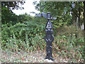
2
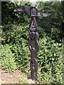
National Cycle Network signpost
Network route 4 runs from Greenwich to Fishguard.
Image: © Steve Daniels
Taken: 25 Jun 2012
0.03 miles
3
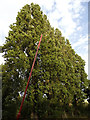
Poplars along Millard Road
A row of mature poplar trees. The trees are vertical; it is the lamp post that is leaning alarmingly (but deliberately, as all the other lamp posts in this park are at a similar angle).
Image: © Stephen Craven
Taken: 21 Aug 2013
0.03 miles
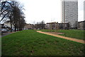
5
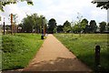
The Thames Path through Pepys Park
The path runs from the Thames through Pepys Park to Grove Street.
Image: © Steve Daniels
Taken: 25 Jun 2012
0.03 miles
6

Cyclists on National Network Cycleway 4
Route 4 runs between Greenwich and Fishguard.
Image: © Steve Daniels
Taken: 25 Jun 2012
0.04 miles
7
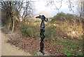
Sustrans milepost at Deptford Strand
The milepost on National Cycle Route 4 indicates 110 miles to Oxford and 115 miles (via route 1) to Dover. The vegetation around it has grown substantially since another contributor photographed it 18 months earlier Image
Image: © Stephen Craven
Taken: 21 Aug 2013
0.04 miles
8
Sustrans milepost at Pepys Park
Route number four goes from London to Fishgard
Image: © Eirian Evans
Taken: 28 Nov 2013
0.04 miles
10
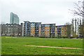
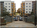
Flats on Millard Road, SE8
Looking across Pepys Park.
Image: © Robin Webster
Taken: 6 Apr 2019
0.04 miles