IMAGES TAKEN NEAR TO
Greenwich Quay, Clarence Road, LONDON, SE8 3EY
Introduction
This page details the photographs taken nearby to Greenwich Quay, Clarence Road, SE8 3EY by members of the Geograph project.
The Geograph project started in 2005 with the aim of publishing, organising and preserving representative images for every square kilometre of Great Britain, Ireland and the Isle of Man.

There are currently over 7.5m images from over14,400 individuals and you can help contribute to the project by visiting https://www.geograph.org.uk
Image Map
Images are licensed for reuse under creativecommons.org/licenses/by-sa/2.0
Notes
- Clicking on the map will re-center to the selected point.
- The higher the marker number, the further away the image location is from the centre of the postcode.
Image Listing (470 Images Found)
Images are licensed for reuse under creativecommons.org/licenses/by-sa/2.0
Image
Details
Distance
1
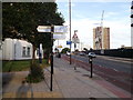
Thames Path on Creek Road
The long distance path leads left along Stowage (road) towards Glaisher Street around Millennium Quay and the River Thames. It also heads straight on along the road towards Greenwich.
The Waterlink Way, another path (leads right, across the road) towards Copperas Street (along Deptford Creek).
Image: © David Anstiss
Taken: 25 Sep 2011
0.02 miles
2
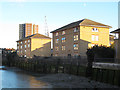
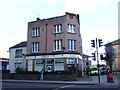
Greenwich Quay
Two of three modern housing blocks along the west side of Deptford Creek.
Image: © Stephen Craven
Taken: 3 Oct 2014
0.02 miles
3
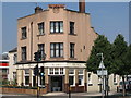
The Hoy, Creek Road, SE8
Formerly a Trumans pub - see Image - now a delicatessen.
Image: © Mike Quinn
Taken: 2 Jul 2009
0.02 miles
4
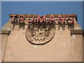
Sign and crest on The Hoy, Creek Road, SE8
See Image
Image: © Mike Quinn
Taken: 2 Jul 2009
0.02 miles
5
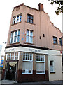
The Hoy, Deptford
I did wonder whether this cafe had been renamed in honour of Britain's Olympic medal winning cyclist Sir Chris Hoy, but no, it has been called that for a long time Image and presumably the name was that of its original incarnation as a Truman's pub.
Image: © Stephen Craven
Taken: 8 Aug 2012
0.03 miles
7
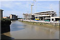
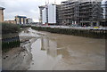
Ravensbourne River
The Ravensbourne River just before it flows into the River Thames at Greenwich. Viewed from the bridge carrying the A200.
Image: © Philip Halling
Taken: 1 Oct 2011
0.03 miles
8
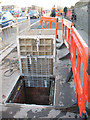
Deptford Creek Bridge: services shaft
According to a site engineer, this manhole cover and its pair the other side of the bridge give access to 20m deep shafts connected by a utility service tunnel under the river.
Image: © Stephen Craven
Taken: 1 Dec 2009
0.03 miles
9
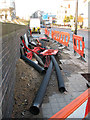
Deptford Creek Bridge: power cables
During November/December 2009, National Grid engineers were relaying high voltage power cables along Creek Road. Because of the lifting bridge Image the cables have to go down into a tunnel under the river. The reason for there being so many HV cables at this location is that there used to be a power station close by (originally Ferranti's plant of 1891, allegedly the largest electrical power station in the world at the time; its successor only closed in 1983).
Image: © Stephen Craven
Taken: 1 Dec 2009
0.03 miles