IMAGES TAKEN NEAR TO
Woolwich Road, LONDON, SE7 8SU
Introduction
This page details the photographs taken nearby to Woolwich Road, SE7 8SU by members of the Geograph project.
The Geograph project started in 2005 with the aim of publishing, organising and preserving representative images for every square kilometre of Great Britain, Ireland and the Isle of Man.

There are currently over 7.5m images from over14,400 individuals and you can help contribute to the project by visiting https://www.geograph.org.uk
Image Map
Images are licensed for reuse under creativecommons.org/licenses/by-sa/2.0
Notes
- Clicking on the map will re-center to the selected point.
- The higher the marker number, the further away the image location is from the centre of the postcode.
Image Listing (138 Images Found)
Images are licensed for reuse under creativecommons.org/licenses/by-sa/2.0
Image
Details
Distance
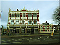
1
The Antigallican, Charlton
An unusually named budget hotel/hostel on the corner of Woolwich Road (foreground) and Charlton Church Lane.
Image: © Stephen Craven
Taken: 18 Apr 2010
0.01 miles
2

The Antigallican, Charlton
The Antigallican pub in Charlton, South East London, photographed on a sunny November afternoon.
The name of the pub is explained in a post on the Greenwich Phantom blog: http://www.thegreenwichphantom.co.uk/2011/12/antigallican/
Image: © Malc McDonald
Taken: 19 Nov 2017
0.01 miles
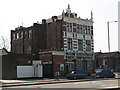
3
The Antigallican, Charlton
The side of the hotel facing Charlton Church Lane. For a view of the side facing Woolwich Road, see Image
Image: © Stephen Craven
Taken: 25 Dec 2013
0.01 miles
6
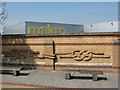
Brick knots
An unusual feature of this wall on Woolwich Road is the depiction of two knots in raised brickwork. A close inspection shows inscriptions naming them as "Double Sheet Bend" and "Carrick Bend" and the sculptor's name as John McKenna.
Image: © Stephen Craven
Taken: 18 Apr 2010
0.05 miles
7

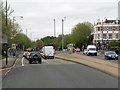
Anchor & Hope Lane, Charlton
Anchor & Hope Lane takes its name from a pub called the Anchor & Hope.
This image was taken on a sunny Sunday afternoon in November, with the trees displaying autumn colour. Traffic was queueing.
In the centre of the road is a bus lane, enabling buses to continue straight ahead when all other approaching vehicles must turn left.
Image: © Malc McDonald
Taken: 19 Nov 2017
0.05 miles
8
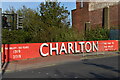
Painted 'Charlton' sign on railway bridge parapet wall
Opposite the exit from Charlton railway station and just a couple of minutes' walk from Charlton's home ground at The Valley.
Image: © David Martin
Taken: 24 Apr 2021
0.06 miles
9
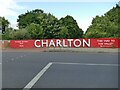
Charlton Athletic centenary mural
Painted on the parapet of a railway bridge on Charlton Church Lane in 2019 to mark the football club's centenary. The colour scheme, lettering and even the arrow are in the style of 1950s British Railways signage. 'The Valley' is the club's stadium.
Image: © Stephen Craven
Taken: 27 Jun 2022
0.06 miles
10
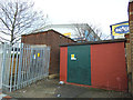
Substation, Anchor and Hope Lane, Charlton
A small electrical substation.
Image: © Stephen Craven
Taken: 25 Dec 2013
0.06 miles