IMAGES TAKEN NEAR TO
Charlton Lane, LONDON, SE7 8LR
Introduction
This page details the photographs taken nearby to Charlton Lane, SE7 8LR by members of the Geograph project.
The Geograph project started in 2005 with the aim of publishing, organising and preserving representative images for every square kilometre of Great Britain, Ireland and the Isle of Man.

There are currently over 7.5m images from over14,400 individuals and you can help contribute to the project by visiting https://www.geograph.org.uk
Image Map
Images are licensed for reuse under creativecommons.org/licenses/by-sa/2.0
Notes
- Clicking on the map will re-center to the selected point.
- The higher the marker number, the further away the image location is from the centre of the postcode.
Image Listing (198 Images Found)
Images are licensed for reuse under creativecommons.org/licenses/by-sa/2.0
Image
Details
Distance
1
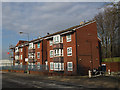
Trinity Court, Charlton Lane
This three-storey apartment block gets its name from the Anglican church (Holy Trinity, New Charlton) which stood on the site from 1894 to 1975. See also Image
Image: © Stephen Craven
Taken: 17 Feb 2013
0.01 miles
2
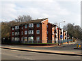
Trinity Court, Charlton Lane
This three-storey apartment block gets its name from the Anglican church (Holy Trinity, New Charlton) which stood on the site from 1894 to 1975. See also Image
Image: © Stephen Craven
Taken: 17 Feb 2013
0.01 miles
3
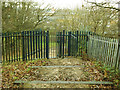
Gate to Maryon Park
One of several gates into the park, this one leads from the Gilberts Pit SSSI into
the flat lower section of the park where there used to be houses.
Image: © Stephen Craven
Taken: 25 Dec 2013
0.02 miles
4
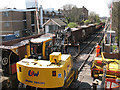
Ballast train at Charlton Lane
The road/rail excavator in the foreground was unloading ballast from a train on the adjacent track, on the level crossing at Charlton Lane. Viewed from the steps to the adjacent footbridge. Behind the ballast wagons is the signal box seen in Image
Image: © Stephen Craven
Taken: 18 Apr 2010
0.03 miles
5
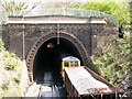
Charlton Tunnel with ballast train
The tunnel portal is seen in Image The train is the one seen in Image and was hauled by a pair of class 73 electro-diesel locomotives.
Image: © Stephen Craven
Taken: 18 Apr 2010
0.03 miles
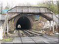
6
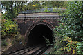
Charlton Lane Tunnel
West portal of Charlton Lane tunnel.
The railway lines burrow under Maryon Park en route to Woolwich Dockyard Station.
Image: © Chris Heaton
Taken: 24 Oct 2016
0.03 miles
7
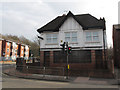
Mount Horeb International Christian Centre
This building on the corner of Woolwich Road (foreground) and Charlton Lane was until a few years ago the Horse and Groom pub. The bracket for its inn sign can still be seen. It is now the base of a branch of the Cherubim and Seraphim church.
Image: © Stephen Craven
Taken: 17 Feb 2013
0.03 miles
8
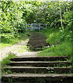
Maryon Park, Charlton SE7
Steps leading to the summit of Cox's Mount from a gate on the Charlton Athletic Football Club side of Charlton Lane, adjacent to the Charlton Lane railway crossing. Cox's mount is the highest point of Gilbert's Pit, an area that was worked for fine sand from c.1780s until 1889. This former pit is now part of Maryon Park but is separated from it by an ascending spur of land that juts out in the direction of the River Thames. Evidence has been uncovered in the past of a Romano-British settlement on Cox's Mount between C1st-C5th.
Image: © David Hallam-Jones
Taken: 4 May 2014
0.03 miles
9
Maryon Park tunnels
Three short tunnels with brief open stretches of line in between take the railway through Maryon Park. This is the westernmost portal with the footbridge adjacent to Image
Image: © Stephen Craven
Taken: 6 Apr 2008
0.04 miles
10
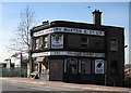
Charlton: The Victoria public house (closed)
Nine months on from Stephen's Image and the pub, with its carved eagle over the entrance door, still exists. Truman Hanbury and Buxton's brewery was the Black Eagle in Spitalfields, and their beers were named after it, as evidenced by the sign on the right side of the building. The brewery was one of the oldest in London, having been acquired by Joseph Truman in 1698. The Truman Hanbury and Buxton name eventually disappeared when they merged with Watney Mann in 1974, the latter having been bought themselves by Grand Metropolitan Hotels in 1972.
The pub, which is at 757 Woolwich Road, is under threat but it is to be hoped that it can be incorporated into whatever is subsequently built on the site.
Image: © Nigel Cox
Taken: 5 Mar 2008
0.04 miles