IMAGES TAKEN NEAR TO
Guild Road, LONDON, SE7 8HP
Introduction
This page details the photographs taken nearby to Guild Road, SE7 8HP by members of the Geograph project.
The Geograph project started in 2005 with the aim of publishing, organising and preserving representative images for every square kilometre of Great Britain, Ireland and the Isle of Man.

There are currently over 7.5m images from over14,400 individuals and you can help contribute to the project by visiting https://www.geograph.org.uk
Image Map
Images are licensed for reuse under creativecommons.org/licenses/by-sa/2.0
Notes
- Clicking on the map will re-center to the selected point.
- The higher the marker number, the further away the image location is from the centre of the postcode.
Image Listing (64 Images Found)
Images are licensed for reuse under creativecommons.org/licenses/by-sa/2.0
Image
Details
Distance
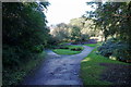
1
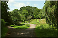
Path junctions, Maryon Wilson Park
The Green Chain Walk keeps right here.
Image: © Derek Harper
Taken: 26 Jun 2019
0.03 miles
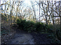
2
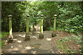
Posts and steps, Maryon Wilson Park
Image] shows the path leading away behind the camera.
Image: © Derek Harper
Taken: 26 Jun 2019
0.05 miles
3
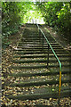
Steps, Maryon Wilson Park
Looking up the flight of steps on the path shown in Image
Image: © Derek Harper
Taken: 26 Jun 2019
0.05 miles
4
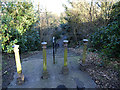
Steps in Maryon Wilson Park
The handrail to these steps looks modern, but the four bollards at the top look like original 19th century cast iron.
Image: © Stephen Craven
Taken: 16 Feb 2014
0.06 miles
6
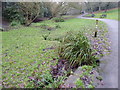
Stream through Maryon Wilson Park in winter
The land now taken up by Maryon Wilson Park was once part of the Hanging Wood which originally stretched from Woolwich Common to Charlton and which provided shelter for the highwaymen of Shooters Hill and Blackheath. Samuel Pepys often told of his dread of Hanging Wood when he was obliged to travel to Woolwich. Although still woodland it is rather more peaceful nowadays. The path followed by the Green Chain Walk and Capital Ring climbs steadily from the Thames through Maryon Park and then Maryon Wilson Park to reach the exit opposite Cemetery Lane. This view looks down the stream which runs through the park.
Image: © Marathon
Taken: 31 Jan 2017
0.06 miles
7

Maryon Wilson Park in winter
The land now taken up by Maryon Wilson Park was once part of the Hanging Wood which originally stretched from Woolwich Common to Charlton and which provided shelter for the highwaymen of Shooters Hill and Blackheath. Samuel Pepys often told of his dread of Hanging Wood when he was obliged to travel to Woolwich. Although still woodland it is rather more peaceful nowadays. The path followed by the Green Chain Walk and Capital Ring climbs steadily from the Thames through Maryon Park and then Maryon Wilson Park to reach the exit opposite Cemetery Lane. This view looks up the stream which runs down through the park.
Image: © Marathon
Taken: 31 Jan 2017
0.06 miles
8
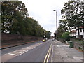
Charlton Park Road
Leading from Woolwich to Charlton.
Behind the wall on the left is a running track in Charlton Park. Currently being used as an Olympic training site.
Image: © David Anstiss
Taken: 11 Sep 2011
0.07 miles
10
Fallen tree in Maryon Wilson Park (2)
One of several trees brought down by the storms of February 2014. See also Image
Image: © Stephen Craven
Taken: 16 Feb 2014
0.08 miles