IMAGES TAKEN NEAR TO
Henry Kenny Drive, LONDON, SE7 8FG
Introduction
This page details the photographs taken nearby to Henry Kenny Drive, SE7 8FG by members of the Geograph project.
The Geograph project started in 2005 with the aim of publishing, organising and preserving representative images for every square kilometre of Great Britain, Ireland and the Isle of Man.

There are currently over 7.5m images from over14,400 individuals and you can help contribute to the project by visiting https://www.geograph.org.uk
Image Map
Images are licensed for reuse under creativecommons.org/licenses/by-sa/2.0
Notes
- Clicking on the map will re-center to the selected point.
- The higher the marker number, the further away the image location is from the centre of the postcode.
Image Listing (155 Images Found)
Images are licensed for reuse under creativecommons.org/licenses/by-sa/2.0
Image
Details
Distance
1
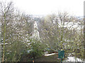
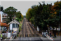
The railway east of Charlton
A straight stretch of line on an otherwise very sinuous line between Greenwich and Woolwich, just west of Image, photographed from above Image
Image: © Stephen Craven
Taken: 6 Apr 2008
0.02 miles
2
Prentiss Court, Charlton
A housing development off Charlton Lane.
Image: © Stephen Craven
Taken: 18 Apr 2010
0.04 miles
3
Hickin Close, Charlton
A fairly modern housing estate between the railway line and the main Woolwich Road.
Image: © Stephen Craven
Taken: 17 Feb 2013
0.04 miles
4
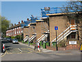
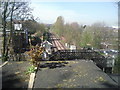
The North Kent Line at Charlton Lane level crossing
This view is taken from above the westernmost tunnel mouth which the North Kent Line goes through between Charlton and Woolwich Dockyard. There are two tunnels beneath Gilbert's Pit and Maryon Park. Charlton Lane just below the tunnel portal here has a busy level crossing and an active signal box, both fairly unusual in the London area. As the crossing gates are often down for fairly lengthy periods, the footbridge is useful. Steps lead up from Charlton Lane past the position from where this photograph was taken to the top of Gilbert's Pit, an old sand quarry, where there are fine views over the Thames
Image: © Marathon
Taken: 7 Apr 2011
0.05 miles
5
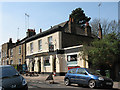
The Royal Oak, Charlton
The pub, on Charlton Lane, was decked with red-and-white bunting, which might have been in anticipation of St George's Day a few days later, or just the colours of the local football team.
Image: © Stephen Craven
Taken: 18 Apr 2010
0.06 miles
6
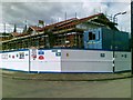
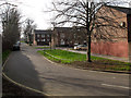
New development, Harvey Gardens, Charlton
Image: © Alex McGregor
Taken: 11 Jul 2012
0.06 miles
7
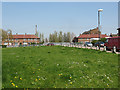
Harvey Gardens, Charlton
Harvey Gardens is an area of housing opposite the Valley stadium, and includes this large open green space.
Image: © Stephen Craven
Taken: 18 Apr 2010
0.07 miles
8
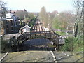
Charlton Lane Signal Box and Crossing
This view is taken from above the westernmost tunnel mouth which the North Kent Line goes through between Charlton and Woolwich Dockyard. There are two tunnels beneath Gilbert's Pit and Maryon Park. Charlton Lane just below the tunnel portal here has a busy level crossing and an active signal box, both fairly unusual in the London area. As the crossing gates are often down for fairly lengthy periods, the footbridge is useful. Steps lead up from Charlton Lane past the position from where this photograph was taken to the top of Gilbert's Pit, an old sand quarry, where there are fine views over the Thames.
Image: © Marathon
Taken: 7 Apr 2011
0.07 miles
9
Railway looking West from Charlton Lane
The lines between Woowich Dockyard and Charlton Stations - seen here at the level crossing at Charlton Lane
Image: © Chris Heaton
Taken: 24 Oct 2016
0.07 miles
10
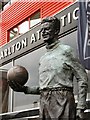
Charlton Athletic, Sam Bartram statue
On Charlton's centenary, 9th June 2005, a statue of Charlton's greatest ever player, goalkeeper Sam Bartram, was unveiled.
Image: © David Hatch
Taken: 9 Jun 2005
0.08 miles