IMAGES TAKEN NEAR TO
Bernard Ashley Drive, LONDON, SE7 7UA
Introduction
This page details the photographs taken nearby to Bernard Ashley Drive, SE7 7UA by members of the Geograph project.
The Geograph project started in 2005 with the aim of publishing, organising and preserving representative images for every square kilometre of Great Britain, Ireland and the Isle of Man.

There are currently over 7.5m images from over14,400 individuals and you can help contribute to the project by visiting https://www.geograph.org.uk
Image Map
Images are licensed for reuse under creativecommons.org/licenses/by-sa/2.0
Notes
- Clicking on the map will re-center to the selected point.
- The higher the marker number, the further away the image location is from the centre of the postcode.
Image Listing (102 Images Found)
Images are licensed for reuse under creativecommons.org/licenses/by-sa/2.0
Image
Details
Distance
1
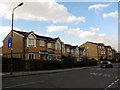
Modern houses on the west side of Victoria Way (1)
These houses form part of the development around Bernard Ashley Drive (a road named after a local author).
Image: © Stephen Craven
Taken: 17 Feb 2013
0.03 miles
2
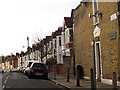
Eastcombe Avenue, Charlton
This is the eastern end of the avenue, which curves down from Charlton Road Image
Image: © Stephen Craven
Taken: 17 Feb 2013
0.03 miles
4
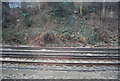
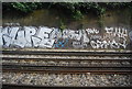
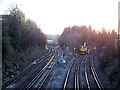
Railway junctions west of Charlton
The four near tracks have split from two at a junction just behind the camera position. The right pair take the direct route to London Bridge via Greenwich, the left pair are a connection to a route via Blackheath and Lewisham. Perhaps the most interesting feature is the crossover and single track turning right off the left hand tracks. This is Angerstein Junction for a freight only branch to Angerstein Wharf. Remarkably it is still in use for imported (probably dredged) aggregate traffic.
Image: © Robin Webster
Taken: 4 Feb 2012
0.05 miles
5
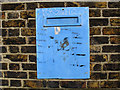
Tory HQ
Someone (a pupil?) has painted this ironic title on the letterbox in the wall of Fossdene School Image
Image: © Stephen Craven
Taken: 17 Feb 2013
0.05 miles
7
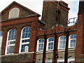
SBL Ao Di 1895
A detail of the view of Fossdene primary school Image shows the SBL (School Board for London) monogram and the date 1895. Unusually the abbreviation Ao Di is used for Anno Domini rather than the more usual AD.
Image: © Stephen Craven
Taken: 17 Feb 2013
0.05 miles
8
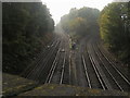
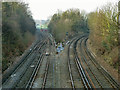
Railway Junction by Victoria Way
From Victoria Way bridge the railway heading left to Blackheath and right to Westcombe Park
Image: © Shaun Ferguson
Taken: 24 Oct 2012
0.05 miles
9
Track maintenance at Charlton Junction
For another view, and history, see Image
Image: © Stephen Craven
Taken: 16 Feb 2014
0.05 miles
10
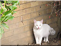
White cat
The cat was in Frank Burton Close Image
Image: © Stephen Craven
Taken: 17 Feb 2013
0.05 miles