IMAGES TAKEN NEAR TO
Troughton Road, LONDON, SE7 7QQ
Introduction
This page details the photographs taken nearby to Troughton Road, SE7 7QQ by members of the Geograph project.
The Geograph project started in 2005 with the aim of publishing, organising and preserving representative images for every square kilometre of Great Britain, Ireland and the Isle of Man.

There are currently over 7.5m images from over14,400 individuals and you can help contribute to the project by visiting https://www.geograph.org.uk
Image Map (Loading...)


Getting Data...Please wait
Leaflet Map data © OpenStreetMap
Images are licensed for reuse under creativecommons.org/licenses/by-sa/2.0
Notes
- Clicking on the map will re-center to the selected point.
- The higher the marker number, the further away the image location is from the centre of the postcode.
Image Listing (143 Images Found)
Images are licensed for reuse under creativecommons.org/licenses/by-sa/2.0
Image
Details
Distance
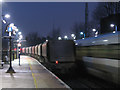
2
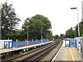
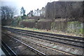
Extending the platforms at Charlton Station
Along with most stations on the North Kent suburban lines, the platforms at Charlton were being extended to take 12-car trains. This end of the platforms is across a grid line from the rest of the station in TQ4178. Beyond the platforms can be seen the junction where direct trains to London take the right-hand pair of tracks, and those on the older route via Blackheath keep left.
Image: © Stephen Craven
Taken: 10 Aug 2013
0.03 miles
3
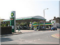
BP service station, Woolwich Road
The price of petrol and diesel was around 120p per litre at this time - the highest it had ever been.
Image: © Stephen Craven
Taken: 18 Apr 2010
0.04 miles
5
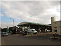
BP filling station, Woolwich Road
Since my previous photo of this facility three years earlier Image the price of petrol had increased from 120 to 136 pence per litre.
Image: © Stephen Craven
Taken: 17 Feb 2013
0.05 miles
6
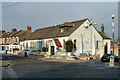
New Covenant Church, Charlton
A pentecostal denomination.
Image: © Bill Boaden
Taken: 11 Oct 2014
0.05 miles
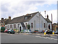
7
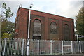
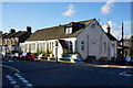
Rathmore Community Centre, Charlton
It has 'Rathmore Youth Centre' over the door. It started out as a mission hall, and retains a religious connection, as the sign on the wall tells us the New Covenant Church meets here at certain times during the week. The building is beset with what at first sight appear to be gaudily upholstered sofas, but are probably painted concrete seats.
Image: © Robin Webster
Taken: 4 Feb 2012
0.05 miles
8
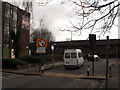
Priority sign on Gallions Road
Gallions Road is a short cut between Woolwich Road and Bugsbys Way. This width restriction with priority signage is probably intended to prevent traffic emerging onto Woolwich Road from getting in the way of large commercial vehicles turning into the road. The "right turn only" sign referred to traffic emerging from the former Wickes car park that has now been closed Image
Image: © Stephen Craven
Taken: 17 Feb 2013
0.07 miles
9
Early morning freight at Charlton
Travelling much earlier than usual, I found this train of empty aggregates wagons trundling slowly through the station at 6.40am. There are no paths free for freight through most of the day on this busy commuter line. See Image for further detail on this freight operation.
What may look in the half-light like a chimney at the right of the photo is in fact a telecoms mast.
Image: © Stephen Craven
Taken: 17 Feb 2010
0.07 miles
10
Rathmore Youth Centre, Troughton Road
Originally the Good Shepherd Mission (the name is still on the end of the building), now a youth centre with gaily painted benches outside.
Image: © Stephen Craven
Taken: 19 Aug 2006
0.08 miles