IMAGES TAKEN NEAR TO
Inverine Road, LONDON, SE7 7NL
Introduction
This page details the photographs taken nearby to Inverine Road, SE7 7NL by members of the Geograph project.
The Geograph project started in 2005 with the aim of publishing, organising and preserving representative images for every square kilometre of Great Britain, Ireland and the Isle of Man.

There are currently over 7.5m images from over14,400 individuals and you can help contribute to the project by visiting https://www.geograph.org.uk
Image Map
Images are licensed for reuse under creativecommons.org/licenses/by-sa/2.0
Notes
- Clicking on the map will re-center to the selected point.
- The higher the marker number, the further away the image location is from the centre of the postcode.
Image Listing (130 Images Found)
Images are licensed for reuse under creativecommons.org/licenses/by-sa/2.0
Image
Details
Distance
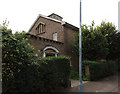
3
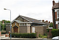
St Richard's church and hall, Charlton
A church hall belonging to St Luke's parish, with a 30-seater chapel beneath the east end used for occasional services. Designed by Ralph Covell and built in 1958.
Image: © Stephen Craven
Taken: 16 Jul 2007
0.05 miles
4
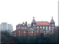
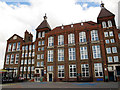
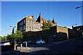
Fossdene School, Charlton
The tall, brick primary school building is typical of several in the area. The topography of the area means that this view from 800m to the west is probably the clearest view of the building's twin towers.
In 2006 the Government planned to rebuild every primary school in the UK by 2020, but that plan has since been severely cut back. These solidly built Victorian schools well may outlast many a late 20th century one.
Image: © Stephen Craven
Taken: 14 Feb 2009
0.05 miles
5
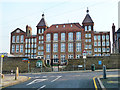
Fossdene School, Charlton
This large primary school dating from 1895 is one of the most prominent buildings in the area, and the only listed building in the extensive area between East Greenwich and Charlton Village. List entry number 1393586, grade 2. This view from the school gate shows the full height of the building but not its full extent. See also Image
Image: © Stephen Craven
Taken: 17 Feb 2013
0.06 miles
6
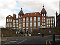
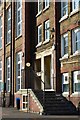
Fossdene Primary School, Charlton
Built 1895, we are told twice, one on each lower wing, unusually not A.D. 1895, but Ao. Di. 1895. The extreme left wing has a 'LSB' monogram at the top, presumably denoting London School Board. The right wing has the bricks on its outer corner ready for meshing with, at a guess, a similar extension, but it was not to be.
Image: © Robin Webster
Taken: 4 Feb 2012
0.06 miles
7
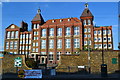
Fossdene School, Charlton
This large primary school dating from 1895 is one of the most prominent buildings in the area, and the only listed building in the extensive area between East Greenwich and Charlton Village. List entry number 1393586, grade 2. See also Image for a distant view.
Image: © Stephen Craven
Taken: 17 Feb 2013
0.06 miles
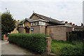
8
Fossdene Primary School
A massive building, arcaded on the far side to compensate for the steep hillside on which it has been built.
Image: © David Martin
Taken: 21 Jun 2014
0.06 miles
9
Fossdene Primary School
An imposing building, while its positioning makes it look more imposing still.
Image: © Bill Boaden
Taken: 11 Oct 2014
0.06 miles
10
Infants' and girls' entrances, Fossdene Primary School
Image: © David Martin
Taken: 21 Jun 2014
0.06 miles