IMAGES TAKEN NEAR TO
Wyndcliff Road, LONDON, SE7 7JY
Introduction
This page details the photographs taken nearby to Wyndcliff Road, SE7 7JY by members of the Geograph project.
The Geograph project started in 2005 with the aim of publishing, organising and preserving representative images for every square kilometre of Great Britain, Ireland and the Isle of Man.

There are currently over 7.5m images from over14,400 individuals and you can help contribute to the project by visiting https://www.geograph.org.uk
Image Map
Images are licensed for reuse under creativecommons.org/licenses/by-sa/2.0
Notes
- Clicking on the map will re-center to the selected point.
- The higher the marker number, the further away the image location is from the centre of the postcode.
Image Listing (163 Images Found)
Images are licensed for reuse under creativecommons.org/licenses/by-sa/2.0
Image
Details
Distance
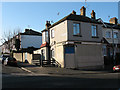
1
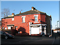
Newsagent on Wyndcliff Road
The shop is at the Corner of Wyndcliff Road (sometimes spelt Wyncliff) and Bramshot Avenue.
Image: © Stephen Craven
Taken: 11 Feb 2010
0.00 miles
2
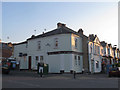
Former wine merchant, Wyndcliff Road, Charlton
In recent years this had been a newsagent Image, but it closed in 2014, and by the following year the previous identity had been revealed as "Arthur Cooper wine merchant, Ltd".
Image: © Stephen Craven
Taken: 30 Jun 2015
0.00 miles
3
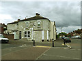
Closed shop on Wyndcliff Road
The shop had already closed by 2015 Image but it appears the building is now receiving some attention, maybe prior to reopening.
Image: © Stephen Craven
Taken: 28 Apr 2019
0.01 miles
4
Junction of Wyndcliff Road and Bramshot Avenue
Image: © Roger Templeman
Taken: 20 Nov 2010
0.03 miles
5
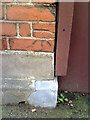
Benchmark on Charlton United Reformed Church
Ordnance Survey cut mark benchmark described on the Bench Mark Database at http://www.bench-marks.org.uk/bm36056
Image: © Roger Templeman
Taken: 20 Nov 2010
0.03 miles
6
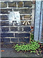
Benchmark on wall pier outside Sherington Primary School
Ordnance Survey cut mark benchmark described on the Bench Mark Database at http://www.bench-marks.org.uk/bm36077
Image: © Roger Templeman
Taken: 20 Nov 2010
0.03 miles
7
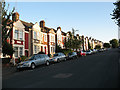
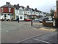
Houses on the east side of Wyndcliff Road
The houses are typical of the larger terraced properties of the late 19th century.
The gradient of the road (approx. 1:17 or 6%) can be clearly seen in this photo.
The spelling of the road name varies locally - Wyncliff, Wyndcliff and Wyndcliffe are all used - but I have taken the name on the actual roadsigns.
Image: © Stephen Craven
Taken: 31 Aug 2009
0.04 miles
8
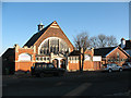
Charlton United Reformed Church
The building is on Bramshot Avenue. It was built in 1908/9 in "arts and crafts" style to the design of Griffin and Woollard. It was intended as the hall of a larger Congregational church that never got built. In 1972 the Congregationalists became part of the URC. The URC now works jointly with the nearby Sunfields Methodist church Image
A fuller history can be found on the church's website at http://www.urccharlton.org/html/body_the_history.html
Image: © Stephen Craven
Taken: 11 Feb 2010
0.04 miles
9
Closed shop on Sherington Road
The building is on the corner of Sherington Road and Bramshot Avenue. It has been closed since at least 2007 (or earlier) and it is not clear what type of business occupied it.
Image: © Stephen Craven
Taken: 11 Feb 2010
0.05 miles
10
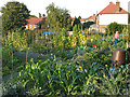
Allotments on Highcombe
Gardeners working on a fine, late summer evening
Image: © Stephen Craven
Taken: 31 Aug 2009
0.05 miles