IMAGES TAKEN NEAR TO
Hopedale Road, LONDON, SE7 7JH
Introduction
This page details the photographs taken nearby to Hopedale Road, SE7 7JH by members of the Geograph project.
The Geograph project started in 2005 with the aim of publishing, organising and preserving representative images for every square kilometre of Great Britain, Ireland and the Isle of Man.

There are currently over 7.5m images from over14,400 individuals and you can help contribute to the project by visiting https://www.geograph.org.uk
Image Map
Images are licensed for reuse under creativecommons.org/licenses/by-sa/2.0
Notes
- Clicking on the map will re-center to the selected point.
- The higher the marker number, the further away the image location is from the centre of the postcode.
Image Listing (178 Images Found)
Images are licensed for reuse under creativecommons.org/licenses/by-sa/2.0
Image
Details
Distance
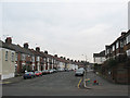
1
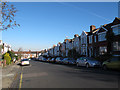
Mayhill Road
A residential street typical of this area developed on what had been farmland in the early 20th century.
Image: © Stephen Craven
Taken: 18 Nov 2012
0.04 miles
2
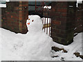
Snowman with hat
This snow figure on Mayhill Road had been given a head covering, unlike most others in the sequence.
Image: © Stephen Craven
Taken: 5 Feb 2012
0.04 miles
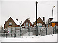
4
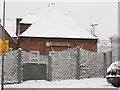
Art Room of Sherington School
The building bears the original name of "art room" though it may be used for some different activity these days. This building is just up the hill (south) from the Children's Centre Image
The photo was taken just after 5cm of snow had fallen.
Image: © Stephen Craven
Taken: 18 Dec 2010
0.06 miles
5
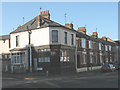
The Bramdale Laundrette (closed)
The laundrette (sic) had already gone out of business when I moved to the area in 2007, and judging by the faded lettering it had already been closed for some time. It took its name from the two roads on the corner of which it stands: Bramshot Avenue and Hopedale Road.
Image: © Stephen Craven
Taken: 11 Feb 2010
0.06 miles
6
Sherington Children's Centre
Part of Sherington School [for main entrance on Wyndcliff Road, see Image This entrance is on Sherington Road.
The photo was taken just after a heavy snowfall had deposited about 5cm of snow in 2 hours.
Image: © Stephen Craven
Taken: 18 Dec 2010
0.06 miles
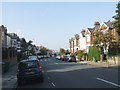
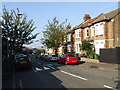
8
Bramshot Avenue, Charlton
Much of Charlton lies on the slope between the Blackheath plateau and the former marshes of East Greenwich. Some of the roads such as this one run horizontally along the hillside, and others down it.
Image: © Stephen Craven
Taken: 14 Feb 2009
0.07 miles
9
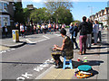
London Marathon 2014: drummer
Along the route, various musicians encourage the runners with upbeat music, such as this drummer.
Image: © Stephen Craven
Taken: 13 Apr 2014
0.07 miles
10
Sherington Primary School (2)
The playground and other buildings of the school whose main entrance is shown in Image
Image: © Stephen Craven
Taken: 11 Feb 2010
0.07 miles