IMAGES TAKEN NEAR TO
Bramshot Avenue, LONDON, SE7 7JF
Introduction
This page details the photographs taken nearby to Bramshot Avenue, SE7 7JF by members of the Geograph project.
The Geograph project started in 2005 with the aim of publishing, organising and preserving representative images for every square kilometre of Great Britain, Ireland and the Isle of Man.

There are currently over 7.5m images from over14,400 individuals and you can help contribute to the project by visiting https://www.geograph.org.uk
Image Map
Images are licensed for reuse under creativecommons.org/licenses/by-sa/2.0
Notes
- Clicking on the map will re-center to the selected point.
- The higher the marker number, the further away the image location is from the centre of the postcode.
Image Listing (163 Images Found)
Images are licensed for reuse under creativecommons.org/licenses/by-sa/2.0
Image
Details
Distance
1
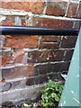
Benchmark on #69 Bramshot Avenue
Ordnance Survey cut mark benchmark described on the Bench Mark Database at http://www.bench-marks.org.uk/bm36078
Image: © Roger Templeman
Taken: 20 Nov 2010
0.02 miles
2
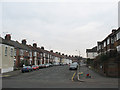
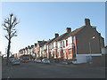
Bramshot Avenue, Charlton
Much of Charlton lies on the slope between the Blackheath plateau and the former marshes of East Greenwich. Some of the roads such as this one run horizontally along the hillside, and others down it.
Image: © Stephen Craven
Taken: 14 Feb 2009
0.02 miles
3
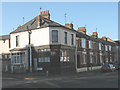
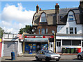
The Bramdale Laundrette (closed)
The laundrette (sic) had already gone out of business when I moved to the area in 2007, and judging by the faded lettering it had already been closed for some time. It took its name from the two roads on the corner of which it stands: Bramshot Avenue and Hopedale Road.
Image: © Stephen Craven
Taken: 11 Feb 2010
0.02 miles
4
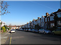
Mayhill Road
A residential street typical of this area developed on what had been farmland in the early 20th century.
Image: © Stephen Craven
Taken: 18 Nov 2012
0.03 miles
5
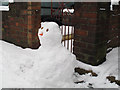
Snowman with hat
This snow figure on Mayhill Road had been given a head covering, unlike most others in the sequence.
Image: © Stephen Craven
Taken: 5 Feb 2012
0.05 miles
6
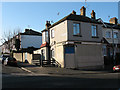
Closed shop on Sherington Road
The building is on the corner of Sherington Road and Bramshot Avenue. It has been closed since at least 2007 (or earlier) and it is not clear what type of business occupied it.
Image: © Stephen Craven
Taken: 11 Feb 2010
0.06 miles
7
Eastcombe Avenue
Looking up Eastcombe Avenue from the junction with Bramshot Avenue. The bus is on route 380 towards Belmarsh via Woolwich.
Image: © Stephen Craven
Taken: 11 Feb 2010
0.06 miles
8
Last of the News of the World
The Toybox Newsagent on Bramshot Avenue had for a long time advertised, like many others, the popular newspapers including the News of the World. The latter title was due to publish its last ever edition on 10 July 2011 (the day after this photo was taken) after being hit by a scandal about the illegal practice of phone-tapping.
Image: © Stephen Craven
Taken: 9 Jul 2011
0.06 miles
9
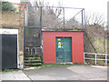
Electricity substation, Bramshot Avenue
Image: © Stephen Craven
Taken: 14 Feb 2009
0.08 miles
10
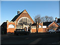
Charlton United Reformed Church
The building is on Bramshot Avenue. It was built in 1908/9 in "arts and crafts" style to the design of Griffin and Woollard. It was intended as the hall of a larger Congregational church that never got built. In 1972 the Congregationalists became part of the URC. The URC now works jointly with the nearby Sunfields Methodist church Image
A fuller history can be found on the church's website at http://www.urccharlton.org/html/body_the_history.html
Image: © Stephen Craven
Taken: 11 Feb 2010
0.08 miles