IMAGES TAKEN NEAR TO
Woolwich Road, SE7 7FY
Introduction
This page details the photographs taken nearby to Woolwich Road, SE7 7FY by members of the Geograph project.
The Geograph project started in 2005 with the aim of publishing, organising and preserving representative images for every square kilometre of Great Britain, Ireland and the Isle of Man.

There are currently over 7.5m images from over14,400 individuals and you can help contribute to the project by visiting https://www.geograph.org.uk
Image Map
Images are licensed for reuse under creativecommons.org/licenses/by-sa/2.0
Notes
- Clicking on the map will re-center to the selected point.
- The higher the marker number, the further away the image location is from the centre of the postcode.
Image Listing (127 Images Found)
Images are licensed for reuse under creativecommons.org/licenses/by-sa/2.0
Image
Details
Distance
1
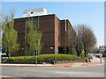
Valley House, Woolwich Road
Valley House is a Greenwich Council office building with several teams in the social services and housing sectors.
Image: © Stephen Craven
Taken: 18 Apr 2010
0.01 miles
2
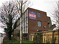
Valley House, sold
Since my previous photo three years ago Image this Council office has been closed and sold, probably for demolition as part of redevelopment of the adjacent site.
Image: © Stephen Craven
Taken: 17 Feb 2013
0.01 miles
3
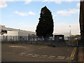
Tree in a car park
The car park round the back of Makro Image has been closed off. Within it stands an impressive cypress tree or similar.
Image: © Stephen Craven
Taken: 17 Feb 2013
0.02 miles
4
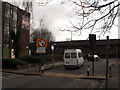
Priority sign on Gallions Road
Gallions Road is a short cut between Woolwich Road and Bugsbys Way. This width restriction with priority signage is probably intended to prevent traffic emerging onto Woolwich Road from getting in the way of large commercial vehicles turning into the road. The "right turn only" sign referred to traffic emerging from the former Wickes car park that has now been closed Image
Image: © Stephen Craven
Taken: 17 Feb 2013
0.03 miles
5
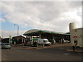
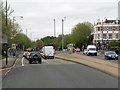
BP filling station, Woolwich Road
Since my previous photo of this facility three years earlier Image the price of petrol had increased from 120 to 136 pence per litre.
Image: © Stephen Craven
Taken: 17 Feb 2013
0.05 miles
6
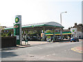
BP service station, Woolwich Road
The price of petrol and diesel was around 120p per litre at this time - the highest it had ever been.
Image: © Stephen Craven
Taken: 18 Apr 2010
0.06 miles
7
Former Wickes store, Gallions Road
Since my previous photo of this site three years earlier Image Wickes had closed to make way for another large retail development.
Image: © Stephen Craven
Taken: 17 Feb 2013
0.06 miles
8
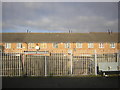
Backs of houses off Charlton station
Image: © Christopher Hilton
Taken: 20 Jan 2016
0.07 miles
10
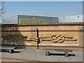
Brick knots
An unusual feature of this wall on Woolwich Road is the depiction of two knots in raised brickwork. A close inspection shows inscriptions naming them as "Double Sheet Bend" and "Carrick Bend" and the sculptor's name as John McKenna.
Image: © Stephen Craven
Taken: 18 Apr 2010
0.07 miles