IMAGES TAKEN NEAR TO
Cavalier Terrace, Bramhope Lane, LONDON, SE7 7FG
Introduction
This page details the photographs taken nearby to Cavalier Terrace, Bramhope Lane, SE7 7FG by members of the Geograph project.
The Geograph project started in 2005 with the aim of publishing, organising and preserving representative images for every square kilometre of Great Britain, Ireland and the Isle of Man.

There are currently over 7.5m images from over14,400 individuals and you can help contribute to the project by visiting https://www.geograph.org.uk
Image Map
Images are licensed for reuse under creativecommons.org/licenses/by-sa/2.0
Notes
- Clicking on the map will re-center to the selected point.
- The higher the marker number, the further away the image location is from the centre of the postcode.
Image Listing (128 Images Found)
Images are licensed for reuse under creativecommons.org/licenses/by-sa/2.0
Image
Details
Distance
1
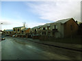
Culloden Close
Part of a recent development around Bramhope Lane, all the blocks of which have Scottish names.
Image: © Stephen Craven
Taken: 25 Dec 2013
0.01 miles
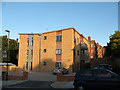
2
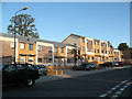
Cavalier Terrace, Bramhope Lane
Cavalier Terrace is part of the SENSE7 development completed in 2008 (see Image ).
Image: © Stephen Craven
Taken: 31 Aug 2009
0.01 miles
3
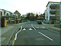
New speed hump on Bramhope Lane
Speed humps had just been introduced in February 2014 to several roads in this area as part of a 20mph zone. They are of the cyclist-friendly "sinusoidal" design.
Image: © Stephen Craven
Taken: 16 Feb 2014
0.02 miles
4
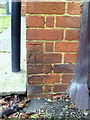
Benchmark on #19 Harold Gibbons Court, Victoria Way
Ordnance Survey cut mark benchmark described on the Bench Mark Database at http://www.bench-marks.org.uk/bm36082
Image: © Roger Templeman
Taken: 20 Nov 2010
0.04 miles
5
New housing on Tallis Grove
This block on the corner of Tallis Grove (foreground) and Victoria Way (left) was built in 2008.
Tallis Grove is presumably named after the composer Thomas Tallis who was a resident of Greenwich.
Image: © Stephen Craven
Taken: 31 Aug 2009
0.04 miles
6
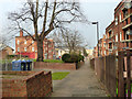
Path, Charlton Triangle estate
The flats here now have had their thermal insulation improved by the novel expedient of applying external cladding to the brickwork.
Image: © Robin Webster
Taken: 4 Feb 2012
0.05 miles
7
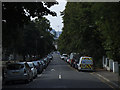
Victoria Way, Charlton
Looking downhill from the junction with Elliscombe Road, with a pylon of the Emirates Air Line visible in the distance.
Image: © Stephen Craven
Taken: 14 Jul 2013
0.06 miles
8
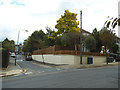
New wall on Mascalls Road
This wall had collapsed in the wet winter of 2014, and had been rebuilt to a higher standard with white-painted render and plenty of weep holes to prevent future build up of water.
Image: © Stephen Craven
Taken: 31 Aug 2014
0.07 miles
9
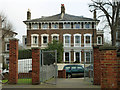
Large semi on Victoria Way
Viewed through the gates of an estate of flats of very different architecture.
Image: © Robin Webster
Taken: 4 Feb 2012
0.07 miles
10
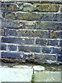
Benchmark on the wall of Wellington Gardens
Ordnance Survey cut mark benchmark described on the Bench Mark Database at http://www.bench-marks.org.uk/bm36084
Image: © Roger Templeman
Taken: 20 Nov 2010
0.09 miles