IMAGES TAKEN NEAR TO
Charlton Road, LONDON, SE7 7DW
Introduction
This page details the photographs taken nearby to Charlton Road, SE7 7DW by members of the Geograph project.
The Geograph project started in 2005 with the aim of publishing, organising and preserving representative images for every square kilometre of Great Britain, Ireland and the Isle of Man.

There are currently over 7.5m images from over14,400 individuals and you can help contribute to the project by visiting https://www.geograph.org.uk
Image Map
Images are licensed for reuse under creativecommons.org/licenses/by-sa/2.0
Notes
- Clicking on the map will re-center to the selected point.
- The higher the marker number, the further away the image location is from the centre of the postcode.
Image Listing (175 Images Found)
Images are licensed for reuse under creativecommons.org/licenses/by-sa/2.0
Image
Details
Distance
1
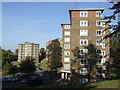
Blocks of flats, Charlton
Blocks of flats in Charlton, South East London.
Image: © Malc McDonald
Taken: 22 Oct 2011
0.03 miles
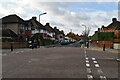
3
Springfield Grove (2)
Several tower blocks comprise the housing along Springfield Grove, which runs parallel to but lower than the main Charlton Road from which this photo was taken. See also Image
Image: © Stephen Craven
Taken: 18 Oct 2009
0.06 miles
4
Springfield Grove (1)
Several tower blocks comprise the housing along Springfield Grove, which runs parallel to but lower than the main Charlton Road from which this photo was taken.
Image: © Stephen Craven
Taken: 18 Oct 2009
0.06 miles
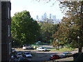
5
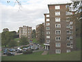
Housing estate, Charlton
These flats are part of a housing estate in Charlton, South East London.
Image: © Malc McDonald
Taken: 22 Oct 2011
0.06 miles
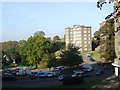
6
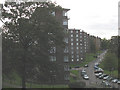
Estate with a view, Charlton
This housing estate in Charlton, South East London, is built on a hillside. The view looks over towards London's Docklands, with the towers of Canary Wharf clearly visible.
Image: © Malc McDonald
Taken: 22 Oct 2011
0.07 miles
8
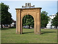
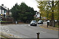
Charlton Road, Charlton, SE7
Charlton Road (i.e. the B210 road) is seen here through the house's original gateway on the building's front lawn. From 1767 the manor and the house belonged to the Maryon-Wilson family who - in 1879 - enclosed the green in front of the house and added it to their grounds, thereby stranding it. The commercial centre of Charlton village is situated to the right of this picture.
Image: © David Hallam-Jones
Taken: 4 May 2014
0.08 miles
9
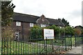
Greenwich Carers Centre
Former Stable buildings of Charlton House. Grade I listed. https://historicengland.org.uk/listing/the-list/list-entry/1079066
Image: © N Chadwick
Taken: 11 Nov 2019
0.08 miles
10
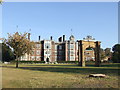
Charlton House
Charlton House is a mansion built during the reign of King James I (1603-1625). It is now a venue for weddings, conferences and events.
Image: © Malc McDonald
Taken: 22 Oct 2011
0.08 miles