IMAGES TAKEN NEAR TO
Marlborough Lane, LONDON, SE7 7DF
Introduction
This page details the photographs taken nearby to Marlborough Lane, SE7 7DF by members of the Geograph project.
The Geograph project started in 2005 with the aim of publishing, organising and preserving representative images for every square kilometre of Great Britain, Ireland and the Isle of Man.

There are currently over 7.5m images from over14,400 individuals and you can help contribute to the project by visiting https://www.geograph.org.uk
Image Map
Images are licensed for reuse under creativecommons.org/licenses/by-sa/2.0
Notes
- Clicking on the map will re-center to the selected point.
- The higher the marker number, the further away the image location is from the centre of the postcode.
Image Listing (104 Images Found)
Images are licensed for reuse under creativecommons.org/licenses/by-sa/2.0
Image
Details
Distance
1
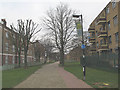
Cherry Orchard estate: cycle route
A shared-use path through the estate, serving the primary school.
Image: © Stephen Craven
Taken: 25 Dec 2009
0.06 miles
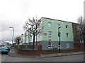
2
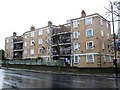
Cedar Court
One of a pair of blocks forming Cedar Court; part of the Cherry Orchard estate in Charlton. This one is on the corner of Marlborough Lane (foreground) and Charlton Road.
Image: © Stephen Craven
Taken: 27 Feb 2011
0.10 miles
3
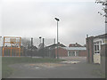
Cherry Orchard primary school
Like most schools these days it is surrounded by a high security fence and this view through the gate was the only one I could get without a fence in the way.
Image: © Stephen Craven
Taken: 25 Dec 2009
0.11 miles
4
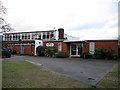
Cherry Orchard school
A primary school on Rectory Field Crescent. See also Image
Image: © Stephen Craven
Taken: 25 Dec 2012
0.11 miles
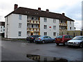
5
Blaker Court
One of several housing blocks comprising this 'court' on Rectory Field Crescent, on the Cherry Orchard estate.
Image: © Stephen Craven
Taken: 25 Dec 2012
0.13 miles
6
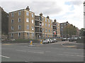
Cherry Orchard, Charlton
The name strictly only applies to the short street in this view with one housing block each side, but is used locally for the whole of the estate to which it gives access. The estate was formerly run by Greenwich Council but now by the Charlton Triangle housing association.
Image: © Stephen Craven
Taken: 18 Oct 2009
0.13 miles
7
The Glades
One of several housing blocks on Rectory Field Crescent, on the Cherry Orchard estate.
Image: © Stephen Craven
Taken: 25 Dec 2012
0.13 miles
8
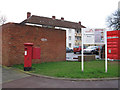
Postbox on Rectory Field Crescent
The housing block behind is The Glades Image
Image: © Stephen Craven
Taken: 25 Dec 2012
0.13 miles
9
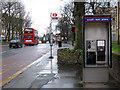
Bus stop and phone on Charlton Road
The bus stop here serves routes 53 to Whitehall; 54 to Elmers End; 422 to North Greenwich. A 422 is seen heading the other way to Bexleyheath. Beyond that the Pelican crossing at the top of Victoria Way is flashing amber.
The phone box is of a recent design that allows customers to send e-mails and texts (although I have not seen anyone use it for that purpose).
Image: © Stephen Craven
Taken: 27 Feb 2011
0.14 miles
10
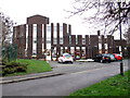
Perrygrove care home
A specialist dementia care unit on Rectory Field Crescent. Designed by Stirling & Gowan and built in 1964. [source: http://daveanderson.me.uk/houses/greenwich.html ]
Image: © Stephen Craven
Taken: 25 Dec 2012
0.14 miles