IMAGES TAKEN NEAR TO
Ravensbourne Park, LONDON, SE6 4XZ
Introduction
This page details the photographs taken nearby to Ravensbourne Park, SE6 4XZ by members of the Geograph project.
The Geograph project started in 2005 with the aim of publishing, organising and preserving representative images for every square kilometre of Great Britain, Ireland and the Isle of Man.

There are currently over 7.5m images from over14,400 individuals and you can help contribute to the project by visiting https://www.geograph.org.uk
Image Map
Images are licensed for reuse under creativecommons.org/licenses/by-sa/2.0
Notes
- Clicking on the map will re-center to the selected point.
- The higher the marker number, the further away the image location is from the centre of the postcode.
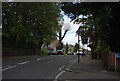
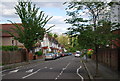
Image Listing (168 Images Found)
Images are licensed for reuse under creativecommons.org/licenses/by-sa/2.0
Image
Details
Distance
2
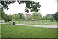
View of flats on Iona Close from Ladywell Fields
Looking south-southwest with an interesting collection of logs in the foreground.
Image: © Robert Lamb
Taken: 19 Aug 2018
0.05 miles

6
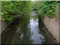
Ravensbourne River, Catford
The Ravensbourne flows to Lewisham where it meets the Quaggy River.
Image: © Danny P Robinson
Taken: 12 May 2007
0.07 miles