IMAGES TAKEN NEAR TO
Ravensbourne Park, LONDON, SE6 4XY
Introduction
This page details the photographs taken nearby to Ravensbourne Park, SE6 4XY by members of the Geograph project.
The Geograph project started in 2005 with the aim of publishing, organising and preserving representative images for every square kilometre of Great Britain, Ireland and the Isle of Man.

There are currently over 7.5m images from over14,400 individuals and you can help contribute to the project by visiting https://www.geograph.org.uk
Image Map
Images are licensed for reuse under creativecommons.org/licenses/by-sa/2.0
Notes
- Clicking on the map will re-center to the selected point.
- The higher the marker number, the further away the image location is from the centre of the postcode.
Image Listing (173 Images Found)
Images are licensed for reuse under creativecommons.org/licenses/by-sa/2.0
Image
Details
Distance

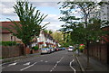
4
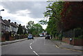
Westdown Road, SE6
At the junction of Bournville Road.
Image: © Danny P Robinson
Taken: 12 May 2007
0.05 miles

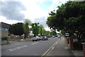
7
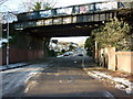
Catford: Ravensbourne Park
'Ravensbourne Park' is a street name rather than a leisure area. Over half a mile in length, it is much in use as a 'rat run'. The overbridge carries the Catford Loop line
Image: © Dr Neil Clifton
Taken: 23 Aug 2012
0.06 miles
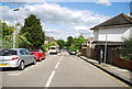
9
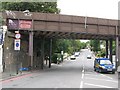
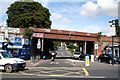
Ravensbourne Park, SE6
The bridge carries the railway line into Catford station just to the north (right).
Image: © Mike Quinn
Taken: 5 Aug 2009
0.07 miles