IMAGES TAKEN NEAR TO
Thomas Lane, LONDON, SE6 4RQ
Introduction
This page details the photographs taken nearby to Thomas Lane, SE6 4RQ by members of the Geograph project.
The Geograph project started in 2005 with the aim of publishing, organising and preserving representative images for every square kilometre of Great Britain, Ireland and the Isle of Man.

There are currently over 7.5m images from over14,400 individuals and you can help contribute to the project by visiting https://www.geograph.org.uk
Image Map
Images are licensed for reuse under creativecommons.org/licenses/by-sa/2.0
Notes
- Clicking on the map will re-center to the selected point.
- The higher the marker number, the further away the image location is from the centre of the postcode.
Image Listing (218 Images Found)
Images are licensed for reuse under creativecommons.org/licenses/by-sa/2.0
Image
Details
Distance
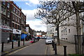
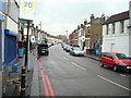
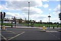
3
Catford Road, Catford
This is the A205, South Circular Road, approaching the junction of the A21.
Image: © Danny P Robinson
Taken: 27 Aug 2006
0.01 miles
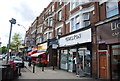
7
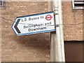
L3 bus stop
This bus stop for long gone route L3 is still found in Catford Shopping Centre in 2014. Route L3 ran between Catford and Downham (later extended to Bromley) between 1988 and 1990.
Image: © Paul
Taken: 11 May 2014
0.04 miles
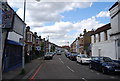
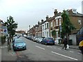
9
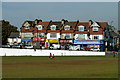
Shops, Catford Road
The road is ramping up to cross the railway at Catford Bridge station.
Image: © Robin Webster
Taken: 1 Oct 2011
0.04 miles