IMAGES TAKEN NEAR TO
Exbury Road, LONDON, SE6 4NA
Introduction
This page details the photographs taken nearby to Exbury Road, SE6 4NA by members of the Geograph project.
The Geograph project started in 2005 with the aim of publishing, organising and preserving representative images for every square kilometre of Great Britain, Ireland and the Isle of Man.

There are currently over 7.5m images from over14,400 individuals and you can help contribute to the project by visiting https://www.geograph.org.uk
Image Map
Images are licensed for reuse under creativecommons.org/licenses/by-sa/2.0
Notes
- Clicking on the map will re-center to the selected point.
- The higher the marker number, the further away the image location is from the centre of the postcode.
Image Listing (76 Images Found)
Images are licensed for reuse under creativecommons.org/licenses/by-sa/2.0
Image
Details
Distance
3

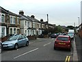
Catford Hill: Kings Church
No external hint of which particular variety of religion it supports, but it appears to still be in use.
Image: © Dr Neil Clifton
Taken: 23 Aug 2012
0.08 miles
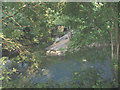
5
Minor tributary of the River Ravensbourne east of Vineyard Close, SE6
Image: © Mike Quinn
Taken: 5 Aug 2009
0.12 miles
8
Confluence of the Pool and the Ravensbourne
These two minor rivers join just south of Catford (the Pool coming in from the right of the picture, and the Ravensbourne from the top). The combined watercourse is called the Ravensbourne though in fact the Pool contributes a greater proportion of the flow.
Image: © Stephen Craven
Taken: 8 Jun 2008
0.13 miles
9
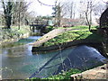
Pool and Ravensbourne Rivers near Catford
The Pool River (entering from the right) and the Ravensbourne River (ahead) join south of Catford. The Pool River flows under a bridge carrying a path and cycleway, while the bridge over the Ravensbourne River carries a railway line.
Image: © Malc McDonald
Taken: 19 Mar 2011
0.13 miles
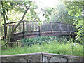
10
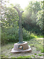
Sustrans milepost, Catford
A milepost on the Waterlink Way (National Cycle Route 21) just south of Catford.
Image: © Stephen Craven
Taken: 8 Jun 2008
0.13 miles