IMAGES TAKEN NEAR TO
Scrooby Street, LONDON, SE6 4JB
Introduction
This page details the photographs taken nearby to Scrooby Street, SE6 4JB by members of the Geograph project.
The Geograph project started in 2005 with the aim of publishing, organising and preserving representative images for every square kilometre of Great Britain, Ireland and the Isle of Man.

There are currently over 7.5m images from over14,400 individuals and you can help contribute to the project by visiting https://www.geograph.org.uk
Image Map
Images are licensed for reuse under creativecommons.org/licenses/by-sa/2.0
Notes
- Clicking on the map will re-center to the selected point.
- The higher the marker number, the further away the image location is from the centre of the postcode.
Image Listing (82 Images Found)
Images are licensed for reuse under creativecommons.org/licenses/by-sa/2.0
Image
Details
Distance
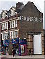
3
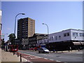
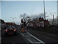
Rushey Green Catford
Rushey Green is the A26
Image: © PAUL FARMER
Taken: 31 May 2009
0.08 miles
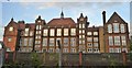
4
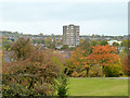
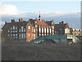
Capital House
47 Rushley Green, seen from Mountsfield Park.
Image: © Robin Webster
Taken: 30 Oct 2011
0.11 miles
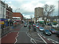
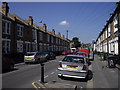
6
Rushey Green, SE6
Approaching the junction of Davenport Road (to right).
Image: © Danny P Robinson
Taken: 25 Feb 2007
0.15 miles
7
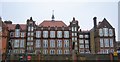
Holbeach Primary School
The school is on Doggett Road but the view is from Ladywell Fields to the north-west, the other side of the railway line.
Image: © Stephen Craven
Taken: 26 Dec 2009
0.16 miles
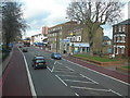
8
Rushey Green, Catford
The road to Lewisham
Image: © David Howard
Taken: 16 Feb 2014
0.16 miles