IMAGES TAKEN NEAR TO
Adenmore Road, LONDON, SE6 4FB
Introduction
This page details the photographs taken nearby to Adenmore Road, SE6 4FB by members of the Geograph project.
The Geograph project started in 2005 with the aim of publishing, organising and preserving representative images for every square kilometre of Great Britain, Ireland and the Isle of Man.

There are currently over 7.5m images from over14,400 individuals and you can help contribute to the project by visiting https://www.geograph.org.uk
Image Map
Images are licensed for reuse under creativecommons.org/licenses/by-sa/2.0
Notes
- Clicking on the map will re-center to the selected point.
- The higher the marker number, the further away the image location is from the centre of the postcode.
Image Listing (133 Images Found)
Images are licensed for reuse under creativecommons.org/licenses/by-sa/2.0
Image
Details
Distance
2
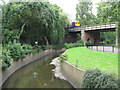
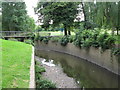
Footbridge in Ladywell Fields
The footbridge carries the Image over the Ravensbourne
Image: © Glyn Baker
Taken: 19 Jul 2017
0.03 miles
3
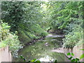
The River Ravensbourne in Ladywell Fields (14)
The River Ravensbourne formerly ran along the eastern edge of the park, hidden behind railings and dense vegetation. The concrete channel is still there in places, but new meanders have been created, running some of the water through the middle of the park - see http://www.therrc.co.uk/case_studies/ladywell_fields.pdf.
Image: © Mike Quinn
Taken: 5 Aug 2009
0.04 miles
4

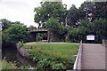
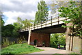
Bridge under the railway, Ladywell Fields
The bridge carries the Catford Loop over the Waterlink Way. Compare Image for a view after the area had been renovated.
Image: © Stephen Craven
Taken: 8 Jun 2008
0.04 miles
5
The River Ravensbourne in Ladywell Fields (16)
The River Ravensbourne formerly ran along the eastern edge of the park, hidden behind railings and dense vegetation. The concrete channel is still there in places, but new meanders have been created, running some of the water through the middle of the park - see http://www.therrc.co.uk/case_studies/ladywell_fields.pdf.
Image: © Mike Quinn
Taken: 5 Aug 2009
0.04 miles
6
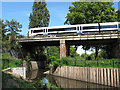
Networker on the Catford Loop
This is a class 465 "Networker" electric multiple unit, crossing the River Ravensbourne on the Catford Loop line (Bromley-Peckham).
Image: © Stephen Craven
Taken: 24 Jul 2011
0.04 miles
8
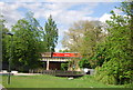
Railway bridge over the River Ravensbourne
Image: © N Chadwick
Taken: 12 May 2012
0.04 miles
9
The River Ravensbourne in Ladywell Fields (15)
The River Ravensbourne formerly ran along the eastern edge of the park, hidden behind railings and dense vegetation. The concrete channel is still there in places, but new meanders have been created, running some of the water through the middle of the park - see http://www.therrc.co.uk/case_studies/ladywell_fields.pdf.
Image: © Mike Quinn
Taken: 5 Aug 2009
0.05 miles
10
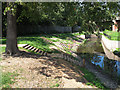
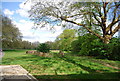
Ladywell Fields: observation steps
As part of the 2010/11 renovation of this area, three sets of steps have been provided down the steep river bank to allow children safely to observe the river and its wildlife at close quarters. For a detail see Image
This photo, taken just 2 months after Image, shows how the grass is beginning to establish itself.
Image: © Stephen Craven
Taken: 24 Jul 2011
0.05 miles