IMAGES TAKEN NEAR TO
Burford Road, LONDON, SE6 4DE
Introduction
This page details the photographs taken nearby to Burford Road, SE6 4DE by members of the Geograph project.
The Geograph project started in 2005 with the aim of publishing, organising and preserving representative images for every square kilometre of Great Britain, Ireland and the Isle of Man.

There are currently over 7.5m images from over14,400 individuals and you can help contribute to the project by visiting https://www.geograph.org.uk
Image Map
Images are licensed for reuse under creativecommons.org/licenses/by-sa/2.0
Notes
- Clicking on the map will re-center to the selected point.
- The higher the marker number, the further away the image location is from the centre of the postcode.
Image Listing (63 Images Found)
Images are licensed for reuse under creativecommons.org/licenses/by-sa/2.0
Image
Details
Distance
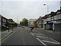
2
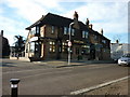
The Perry Hill public house on Perry Hill, Lewisham
Image: © Ian S
Taken: 9 Dec 2010
0.08 miles
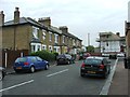
9
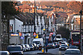
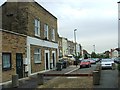
Long view down Perry Hill
The parade of shops is just south of the junction with Woolstone Road.
Image: © David Martin
Taken: 10 Dec 2022
0.14 miles
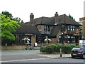
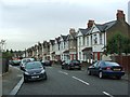
10
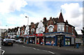
Perry Hill: Shops
At this point, the A212 changes from being Catford Hill (behind the camera) to Perry Hill (in front). The nearer six shops have upper storeys with attractive Dutch-style gables.
Image: © Dr Neil Clifton
Taken: 23 Aug 2012
0.14 miles