IMAGES TAKEN NEAR TO
Athelney Street, LONDON, SE6 3LB
Introduction
This page details the photographs taken nearby to Athelney Street, SE6 3LB by members of the Geograph project.
The Geograph project started in 2005 with the aim of publishing, organising and preserving representative images for every square kilometre of Great Britain, Ireland and the Isle of Man.

There are currently over 7.5m images from over14,400 individuals and you can help contribute to the project by visiting https://www.geograph.org.uk
Image Map
Images are licensed for reuse under creativecommons.org/licenses/by-sa/2.0
Notes
- Clicking on the map will re-center to the selected point.
- The higher the marker number, the further away the image location is from the centre of the postcode.
Image Listing (97 Images Found)
Images are licensed for reuse under creativecommons.org/licenses/by-sa/2.0
Image
Details
Distance
1
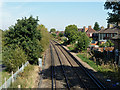
Railway north of Broadmead footbridge
Next stop Catford Bridge.
Image: © Robin Webster
Taken: 1 Oct 2011
0.07 miles
3
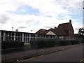
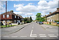
Athelney Primary School, Bellingham
On Athelney Street.
Image: © David Anstiss
Taken: 18 Sep 2011
0.09 miles
5
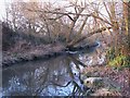
The Pool River east of Datchet Road, SE6 (2)
Image: © Mike Quinn
Taken: 17 Feb 2010
0.09 miles
7
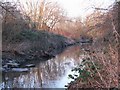
The Pool River east of Datchet Road, SE6 (3)
Image: © Mike Quinn
Taken: 17 Feb 2010
0.09 miles
8
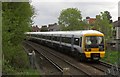
EMU near Catford
A Class 465 Networker EMU seen from beside the footbridge shown in Image, travelling from Catford Bridge to Lower Sydenham. The houses front onto Grangemill Road.
Image: © Derek Harper
Taken: 9 May 2013
0.09 miles
9
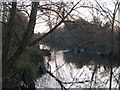
The Pool River east of Datchet Road, SE6
Image: © Mike Quinn
Taken: 17 Feb 2010
0.10 miles
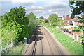
10
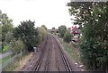
Railway to Catford Bridge
As seen from Image
This line leads from Lower Sydenham towards Catford and onwards to central London.
On the left is the Waterlink Way (cyclepath to Deptford and Greenwich).
Image: © David Anstiss
Taken: 18 Sep 2011
0.10 miles