IMAGES TAKEN NEAR TO
Bromley Road, LONDON, SE6 2RF
Introduction
This page details the photographs taken nearby to Bromley Road, SE6 2RF by members of the Geograph project.
The Geograph project started in 2005 with the aim of publishing, organising and preserving representative images for every square kilometre of Great Britain, Ireland and the Isle of Man.

There are currently over 7.5m images from over14,400 individuals and you can help contribute to the project by visiting https://www.geograph.org.uk
Image Map
Images are licensed for reuse under creativecommons.org/licenses/by-sa/2.0
Notes
- Clicking on the map will re-center to the selected point.
- The higher the marker number, the further away the image location is from the centre of the postcode.
Image Listing (86 Images Found)
Images are licensed for reuse under creativecommons.org/licenses/by-sa/2.0
Image
Details
Distance
3
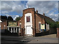
Elim Pentecostal Church and Community Centre, Allerford Road, SE6
Image: © Mike Quinn
Taken: 3 Sep 2009
0.06 miles
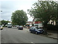
7
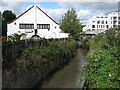
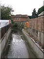
The River Ravensbourne north of Allerford Road, SE6
Image: © Mike Quinn
Taken: 3 Sep 2009
0.08 miles
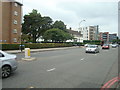
8
The River Ravensbourne south of Orford Road, SE6
Image: © Mike Quinn
Taken: 3 Sep 2009
0.08 miles
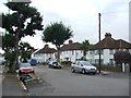
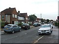
9
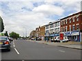
Bromley Road (A21), Bellingham
View north, towards Catford, from a point a little to the south of the junction with Randlesdown Road.
Image: © Stefan Czapski
Taken: 26 Jul 2013
0.08 miles