IMAGES TAKEN NEAR TO
Newquay Road, LONDON, SE6 2NR
Introduction
This page details the photographs taken nearby to Newquay Road, SE6 2NR by members of the Geograph project.
The Geograph project started in 2005 with the aim of publishing, organising and preserving representative images for every square kilometre of Great Britain, Ireland and the Isle of Man.

There are currently over 7.5m images from over14,400 individuals and you can help contribute to the project by visiting https://www.geograph.org.uk
Image Map
Images are licensed for reuse under creativecommons.org/licenses/by-sa/2.0
Notes
- Clicking on the map will re-center to the selected point.
- The higher the marker number, the further away the image location is from the centre of the postcode.
Image Listing (29 Images Found)
Images are licensed for reuse under creativecommons.org/licenses/by-sa/2.0
Image
Details
Distance
2
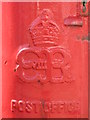
Edward VIII postbox, Crantock Road - royal cipher
See Image
Image: © Mike Quinn
Taken: 9 Apr 2008
0.09 miles
3
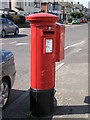
Edward VIII postbox, Crantock Road, SE6
The location of this postbox is shown in Image
Image: © Mike Quinn
Taken: 9 Apr 2008
0.11 miles
4
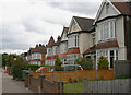
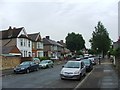
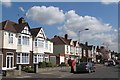
Houses in Bromley Road, London SE6
Whereas the west side of Bromley Road hereabouts is given over to industrial and commercial use, the east side comprises large and mainly multi-occupied properties such as these which lie just to the south of Arran Road.
Image: © David Kemp
Taken: 23 May 2014
0.11 miles
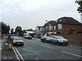
7
Parade of shops, Bromley Road, London SE6
The shops stand adjacent to the corner of Bromley Road and Aitken Road.
Image: © David Kemp
Taken: 23 May 2014
0.13 miles
9
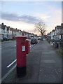
Bellingham: postbox № SE6 56, Crantock Road
One of few pillar boxes to be cast during the short reign of Edward VIII - there are 80 or so still in use. This one is in Crantock Road and is emptied finally at 5:30pm on weekdays and at noon on Saturdays.
See Image for a close-up of the cipher.
Image: © Chris Downer
Taken: 18 Jan 2014
0.15 miles
10
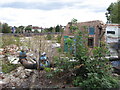
Derelict site between Bromley Road and Franthorne Way, SE6
The buildings shown on the satellite image http://wtp2.appspot.com/wheresthepath.htm?lat=51.43579830207327&lon=-0.01983729572735078&gz=18&oz=10>=1 are no longer there.
Image: © Mike Quinn
Taken: 3 Sep 2009
0.18 miles