IMAGES TAKEN NEAR TO
Culverley Road, LONDON, SE6 2LD
Introduction
This page details the photographs taken nearby to Culverley Road, SE6 2LD by members of the Geograph project.
The Geograph project started in 2005 with the aim of publishing, organising and preserving representative images for every square kilometre of Great Britain, Ireland and the Isle of Man.

There are currently over 7.5m images from over14,400 individuals and you can help contribute to the project by visiting https://www.geograph.org.uk
Image Map
Images are licensed for reuse under creativecommons.org/licenses/by-sa/2.0
Notes
- Clicking on the map will re-center to the selected point.
- The higher the marker number, the further away the image location is from the centre of the postcode.
Image Listing (76 Images Found)
Images are licensed for reuse under creativecommons.org/licenses/by-sa/2.0
Image
Details
Distance
3
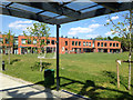
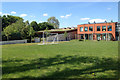
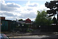
Rushey Green Primary School, view from Penerley Road entrance
A close look shows the zig-zag arrangement of the blocks. The address of this Lewisham Borough school is given as Culverley Road, behind these buildings.
Image: © Robin Stott
Taken: 27 May 2013
0.09 miles
5
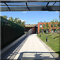
Rushey Green Primary School, view from Penerley Road
The building on the left has a green roof, that is, it's vegetated with low-growing, drought-tolerant species. With its substrate it helps to insulate the building as well as lock up CO2 and provide habitat. The knobbly shadows in the foreground are of pollarded plane trees in the street. The address of this Lewisham Borough school is given as Culverley Road, behind these buildings.
Image: © Robin Stott
Taken: 27 May 2013
0.10 miles
6
Rushey Green Primary School, path from Penerley Road entrance
The building on the left has a green roof, that is, it's vegetated with low-growing, drought-tolerant species. With its substrate it helps to insulate the building as well as lock up CO2 and provide habitat. The knobbly shadow in the foreground is of a pollarded plane tree in the street. The address of this Lewisham Borough school is given as Culverley Road, behind these buildings.
Image: © Robin Stott
Taken: 27 May 2013
0.10 miles
7
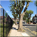
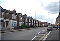
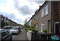
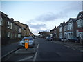
East on Penerley Road, Catford
A residential street lined with pollarded London planes. The fence on the left is to Rushey Green Primary School.
Image: © Robin Stott
Taken: 27 May 2013
0.10 miles
10
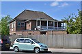
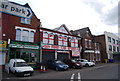
Former clubhouse of Catford Cricket Club, Penerley Road, Catford
Aerial photos show no cricket ground. Perhaps Rushey Green Primary School occupies the site. The building looks as though it may have been divided into flats. The website of the Catford & Cyphers Cricket Club fills in some of the story:
"Catford & Cyphers Cricket Club is a community development cricket club with a history spanning 120 years.
"The club is an amalgamation of three clubs: Catford Cricket Club (1890), formerly of Penerley Road, Catford, Cyphers Cricket Club (1890); formerly of Kings Hall Road, Beckenham and Forest Hill Cricket Club (1882).
"Both Catford and Cyphers lost their historic grounds in the 1970’s and 1980's respectively and now use the old Forest Hill ground, on which cricket has been played for over 100 years. The combined history of the club takes in many fine players who went on to play Minor Counties and County Cricket and in the case of one Jim Laker to become one of the most famous international bowlers of all time." http://www.catfordcyphers.btck.co.uk
Image: © Robin Stott
Taken: 27 May 2013
0.12 miles