IMAGES TAKEN NEAR TO
Bromley Road, LONDON, SE6 2DR
Introduction
This page details the photographs taken nearby to Bromley Road, SE6 2DR by members of the Geograph project.
The Geograph project started in 2005 with the aim of publishing, organising and preserving representative images for every square kilometre of Great Britain, Ireland and the Isle of Man.

There are currently over 7.5m images from over14,400 individuals and you can help contribute to the project by visiting https://www.geograph.org.uk
Image Map
Images are licensed for reuse under creativecommons.org/licenses/by-sa/2.0
Notes
- Clicking on the map will re-center to the selected point.
- The higher the marker number, the further away the image location is from the centre of the postcode.
Image Listing (96 Images Found)
Images are licensed for reuse under creativecommons.org/licenses/by-sa/2.0
Image
Details
Distance
1
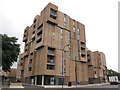
New development on Bromley Road
This block of flats appeared to be just completed.
Image: © Stephen Craven
Taken: 31 Aug 2014
0.01 miles
2
Junction of Southend Lane and Bromley Road
A significant road junction, with traffic lights.
Image: © Stephen Craven
Taken: 31 Aug 2014
0.05 miles
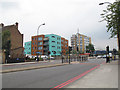
3
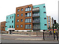
Flats on the site of the Tigers Head
Until a few years ago a large pub stood here, the Tiger's Head. Unfortunately we don't yet have a photo of it on Geograph. These flats have been built on the site.
Image: © Stephen Craven
Taken: 31 Aug 2014
0.05 miles
4
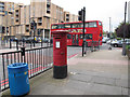
Postbox on Southend Lane
Near the junction with Bromley Road. There is also a litter bin - something that Lewisham is better at providing than most other London Boroughs.
Image: © Stephen Craven
Taken: 31 Aug 2014
0.06 miles
5
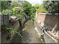
The River Ravensbourne north of Watermead Road, SE6
Image: © Mike Quinn
Taken: 3 Sep 2009
0.07 miles
6
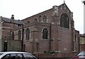
St John the Baptist, Bromley Road, Southend
Image: © John Salmon
Taken: 15 Dec 2008
0.08 miles
7
St John the Baptist, Bromley Road, Southend
Image: © John Salmon
Taken: 15 Dec 2008
0.09 miles
8
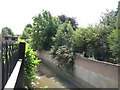
The River Ravensbourne east of Waterbank Road, SE6 (2)
Image: © Mike Quinn
Taken: 3 Sep 2009
0.09 miles
9

Watermead Road, SE6
Image crosses underneath the road in the foreground - but is in a culvert to the south (left).
Image: © Mike Quinn
Taken: 3 Sep 2009
0.09 miles
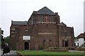
10

St John's church, Beachborough Road
The west end of this Anglican church faces the main Bromley Road but since the west end was never completed it is a plain brick wall. The east end on Beachborough Road is slightly more attractive. Built 1927 and listed Grade 2 (formerly C).
Image: © Stephen Craven
Taken: 13 Aug 2005
0.09 miles