IMAGES TAKEN NEAR TO
South Park Crescent, LONDON, SE6 1JJ
Introduction
This page details the photographs taken nearby to South Park Crescent, SE6 1JJ by members of the Geograph project.
The Geograph project started in 2005 with the aim of publishing, organising and preserving representative images for every square kilometre of Great Britain, Ireland and the Isle of Man.

There are currently over 7.5m images from over14,400 individuals and you can help contribute to the project by visiting https://www.geograph.org.uk
Image Map
Images are licensed for reuse under creativecommons.org/licenses/by-sa/2.0
Notes
- Clicking on the map will re-center to the selected point.
- The higher the marker number, the further away the image location is from the centre of the postcode.
Image Listing (95 Images Found)
Images are licensed for reuse under creativecommons.org/licenses/by-sa/2.0
Image
Details
Distance

9
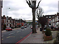
South Circular Road
View looking East along the South Circular towards junction with Verdant Lane.
Image: © David Wright
Taken: 11 Feb 2001
0.08 miles
10
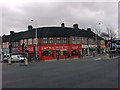
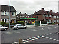
Shopping Parade
Shops at the junction of Brownhill Road (A205 South Circular Road) and Verdant Lane.
Image: © David Wright
Taken: 11 Feb 2001
0.08 miles