IMAGES TAKEN NEAR TO
Pasture Road, LONDON, SE6 1JF
Introduction
This page details the photographs taken nearby to Pasture Road, SE6 1JF by members of the Geograph project.
The Geograph project started in 2005 with the aim of publishing, organising and preserving representative images for every square kilometre of Great Britain, Ireland and the Isle of Man.

There are currently over 7.5m images from over14,400 individuals and you can help contribute to the project by visiting https://www.geograph.org.uk
Image Map
Images are licensed for reuse under creativecommons.org/licenses/by-sa/2.0
Notes
- Clicking on the map will re-center to the selected point.
- The higher the marker number, the further away the image location is from the centre of the postcode.
Image Listing (116 Images Found)
Images are licensed for reuse under creativecommons.org/licenses/by-sa/2.0
Image
Details
Distance
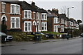
1

Cumberland Place, Hither Green
Cumberland Place is a relatively new development of homes near Hither Green in South East London.
Image: © Malc McDonald
Taken: 25 May 2011
0.06 miles
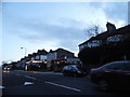
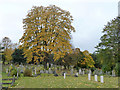
2
Northwest corner of Hither Green Cemetery
Image: © David Martin
Taken: 15 Feb 2022
0.10 miles
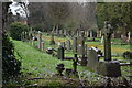
5
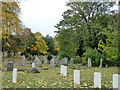
In Hither Green Cemetery
In the older part, originally called Lee Cemetery.
Image: © Robin Webster
Taken: 30 Oct 2011
0.13 miles
7
In Hither Green Cemetery
In the older part, originally called Lee Cemetery.
Image: © Robin Webster
Taken: 30 Oct 2011
0.13 miles