IMAGES TAKEN NEAR TO
Brownhill Road, LONDON, SE6 1AL
Introduction
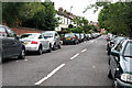
This page details the photographs taken nearby to Brownhill Road, SE6 1AL by members of the Geograph project.
The Geograph project started in 2005 with the aim of publishing, organising and preserving representative images for every square kilometre of Great Britain, Ireland and the Isle of Man.

There are currently over 7.5m images from over14,400 individuals and you can help contribute to the project by visiting https://www.geograph.org.uk
Image Map
Images are licensed for reuse under creativecommons.org/licenses/by-sa/2.0
Notes
- Clicking on the map will re-center to the selected point.
- The higher the marker number, the further away the image location is from the centre of the postcode.
Image Listing (59 Images Found)
Images are licensed for reuse under creativecommons.org/licenses/by-sa/2.0
Image
Details
Distance
1
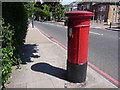
Hither Green: postbox № SE6 25, Brownhill Road
A large Victorian postbox on the South Circular Road, emptied finally at 5:30pm on weekdays and at noon on Saturdays.
Image: © Chris Downer
Taken: 31 May 2009
0.02 miles
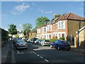
3
Broadfield Road, Hither Green
A residential road much like many others locally.
Image: © Bill Boaden
Taken: 11 Oct 2014
0.04 miles
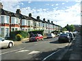
7
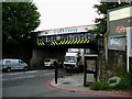
Bottleneck on the A205
This railway bridge is a notorious bottleneck on the A205 South Circular there is a road junction on the east side and another with traffic lights on the west. The bridge restricts four lanes of traffic to three. At rush hours tailback can go for what seems like miles in both directions
Image: © Glyn Baker
Taken: 6 Sep 2005
0.12 miles
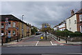
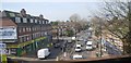
8
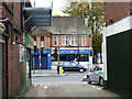
Shops by the junction of Brownhill Road and Verdant Lane
Image: © Bill Boaden
Taken: 11 Oct 2014
0.12 miles
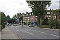
9
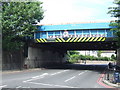
Bridge over the South Circular Road at Lee
This bridge carries the main railway line between London Bridge and Hastings/Dover across the South Circular Road. The bridge is marked with warning signs prohibiting vehicles higher than 14'9" (4.5 metres) nevertheless one of the signs is missing suggesting it may have been struck by an overheight vehicle.
There is no traffic in view, but this is deceptive. The South Circular is a very busy road through South London. However, there are traffic lights just beyond the bridge, and just behind the point where the photograph was taken, this results in occasional quiet moments in between "waves" of heavy traffic.
Image: © Malc McDonald
Taken: 25 May 2011
0.13 miles
10
Istanbul Grill
A sign in the window says 'Close' (sic), only temporary at the time, although later to become permanent.
Image: © Robin Webster
Taken: 30 Oct 2011
0.14 miles