IMAGES TAKEN NEAR TO
Cormont Road, LONDON, SE5 9RQ
Introduction
This page details the photographs taken nearby to Cormont Road, SE5 9RQ by members of the Geograph project.
The Geograph project started in 2005 with the aim of publishing, organising and preserving representative images for every square kilometre of Great Britain, Ireland and the Isle of Man.

There are currently over 7.5m images from over14,400 individuals and you can help contribute to the project by visiting https://www.geograph.org.uk
Image Map
Images are licensed for reuse under creativecommons.org/licenses/by-sa/2.0
Notes
- Clicking on the map will re-center to the selected point.
- The higher the marker number, the further away the image location is from the centre of the postcode.
Image Listing (157 Images Found)
Images are licensed for reuse under creativecommons.org/licenses/by-sa/2.0
Image
Details
Distance
1
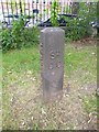
Old Boundary Marker by Cormont Road, Camberwell and Dulwich parish
Parish Boundary Marker by the UC road, in parish of Camberwell and Dulwich (Southwark District), Cormont Road SE5, in park between road and tennis courts, behind railings.
Surveyed
Milestone Society National ID: SY_SGC22pb
Image: © Milestone Society
Taken: Unknown
0.02 miles
2
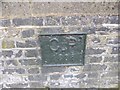
Old Boundary Marker by Cormont Road, Camberwell and Dulwich Parish
Parish Boundary Marker by the UC road, in parish of Camberwell and Dulwich (Southwark District), Cormont Road SE5, on low wall of Myatts Fields in front of tennis courts.
Surveyed
Milestone Society National ID: SY_SGC21pb
Image: © Milestone Society
Taken: Unknown
0.03 miles
4
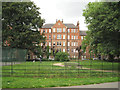
Dog exercise area, Myatt's Fields Park, and Calais Gate flats
Calais Gate comprises two complexes of flats fronting Cormont Road and overlooking the park.
Image: © Robin Stott
Taken: 23 Jun 2013
0.03 miles
5
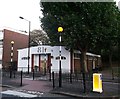
No.81 Ackerman Road, Camberwell
Former church on the road, before it becomes Lothian Road (on the left).
It is now a community centre and office about the re-development of the area.
Image: © David Anstiss
Taken: 2 Oct 2011
0.03 miles
6
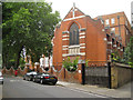
Chapel, St Gabriel's Manor, Cormont Road
St Gabriel's College was built in 1900 as a training college for women teachers and soon became a seminary for Anglican priests. A chapel was added and consecrated in 1903. From the beginning of the First World War in August 1914, the male students having enlisted, the College became home to the First London General Hospital. It dealt with casualties of the war, closing in 1919. After the war, and certainly during the 1930s it resumed life as a teacher training college for women. It was converted into flats in the mid-1990s. Information from: http://www.british-history.ac.uk/report.aspx?compid=49775 http://www.ezitis.myzen.co.uk/firstlondon.html and http://www.youtube.com/watch?v=1tVa_p9Ia3E
In the photo is postbox number SE5 29
Image: © Robin Stott
Taken: 23 Jun 2013
0.04 miles
7

Camberwell, Carlisle Gate
Entrance to Myatt's Fields Park: http://www.myattsfieldspark.info/
Image: © Mike Faherty
Taken: 24 Jun 2014
0.04 miles
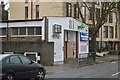
8
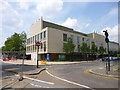
Camberwell, Akerman Health Centre
At the corner of Akerman and Patmos Roads: http://www.akermanmedicalpractice.com/
Image: © Mike Faherty
Taken: 24 Jun 2014
0.05 miles
9

Camberwell, Myatt's Fields Park
On land donated by philanthropist William Minet in 1882, and named after market gardener Joseph Mynett who grew fruit here. The park offers open space, community and sports facilities: http://www.myattsfieldspark.info/
Image: © Mike Faherty
Taken: 24 Jun 2014
0.05 miles
10
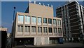
Akerman Health Centre
Part of the new Oval Quarter development.
Image: © David Martin
Taken: 11 Mar 2016
0.05 miles