IMAGES TAKEN NEAR TO
Baldwin Crescent, LONDON, SE5 9LQ
Introduction
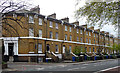
This page details the photographs taken nearby to Baldwin Crescent, SE5 9LQ by members of the Geograph project.
The Geograph project started in 2005 with the aim of publishing, organising and preserving representative images for every square kilometre of Great Britain, Ireland and the Isle of Man.

There are currently over 7.5m images from over14,400 individuals and you can help contribute to the project by visiting https://www.geograph.org.uk
Image Map
Images are licensed for reuse under creativecommons.org/licenses/by-sa/2.0
Notes
- Clicking on the map will re-center to the selected point.
- The higher the marker number, the further away the image location is from the centre of the postcode.
Image Listing (171 Images Found)
Images are licensed for reuse under creativecommons.org/licenses/by-sa/2.0
Image
Details
Distance
1
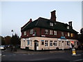
Prince of Wales, Public House, Camberwell
At the roundabout junction of Knatchbull Road (on the left) and Denmark Road (on the right).
Image: © David Anstiss
Taken: 2 Oct 2011
0.08 miles
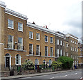
2
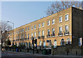
262-276 Camberwell New Road
A noble terrace, probably c1830, of two-bay, three storey houses over basements. Arched ground floor windows set in recessed arches, and first-floor wrought-iron balconies. The group is unified by the first-floor sillband, and cornice and blocking course at the top. Grade II listed.
The listing suggests some fronts have been rebuilt - the nearest two look likely candidates.
Image: © Stephen Richards
Taken: 21 Apr 2012
0.09 miles
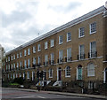
3
254-260 Camberwell New Road
A characteristically happy congregation of Georgian houses, not uniform, but displaying the era's good proportions and homely scale. Mostly of three storeys plus basement, two bays wide, arched ground floor windows, some cast-iron balconies, and a continuous stucco cornice. Early C19th. Grade II listed.
Image: © Stephen Richards
Taken: 15 Apr 2012
0.09 miles
4
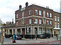
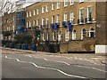
Former King William IV, Camberwell New Road
A typical pub of the former Truman Hanbury Buxton Brewery. Probably built some time between the wars and possibly designed by A.E. Sewell.
Apparently it closed in 2007.
Image: © Stephen Richards
Taken: 15 Apr 2012
0.10 miles
5
236-252 Camberwell New Road
According to the listing, a terrace of c1842, but why not c1840? The pilasters are topped by oversized brackets. Quite a grand entrance round the corner in County Grove. Grade II listed.
Image: © Stephen Richards
Taken: 15 Apr 2012
0.10 miles
6
257-281 Camberwell New Road
A plain but dignified early-C19th stock brick terrace of two-bay houses in three storeys plus basement. The ground-floor windows are round-arched, and the first-floor windows have cast-iron balconies. Grade II listed.
Image: © Stephen Richards
Taken: 11 Mar 2012
0.10 miles
7
Dissent in London
Camberwell New Road
Image: © Brian Whittle
Taken: 16 Feb 2019
0.11 miles
8
Camberwell station frontage
Camberwell was once a station on the City branch of the London Chatham & Dover Railway whose line still runs into London (Blackfriars) and beyond. Camberwell opened in 1862 but closed to passengers in 1916 as a wartime economy. By that time much of its traffic had been syphoned off by competing tramways and it did not reopen.
Image: © David Kemp
Taken: 16 Aug 2014
0.11 miles
9
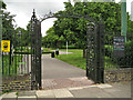
Gates, eastern entrance to Myatt's Fields Park
Behind the camera is the five-way junction of Calais Street, Flodden Road, Knatchbull Road and Denmark Road SE5.
Image: © Robin Stott
Taken: 23 Jun 2013
0.11 miles
10
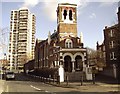
Calvary Temple and Laird House, Camberwell
Calvary Temple is on Councillor Street, Camberwell. Behind is Laird House, one of 5 tower blocks on the Wyndham Estate.
Image: © graham ross
Taken: 10 Feb 2006
0.11 miles