IMAGES TAKEN NEAR TO
Denmark Road, LONDON, SE5 9LB
Introduction
This page details the photographs taken nearby to Denmark Road, SE5 9LB by members of the Geograph project.
The Geograph project started in 2005 with the aim of publishing, organising and preserving representative images for every square kilometre of Great Britain, Ireland and the Isle of Man.

There are currently over 7.5m images from over14,400 individuals and you can help contribute to the project by visiting https://www.geograph.org.uk
Image Map
Images are licensed for reuse under creativecommons.org/licenses/by-sa/2.0
Notes
- Clicking on the map will re-center to the selected point.
- The higher the marker number, the further away the image location is from the centre of the postcode.
Image Listing (107 Images Found)
Images are licensed for reuse under creativecommons.org/licenses/by-sa/2.0
Image
Details
Distance
1
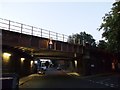
Railway bridge over Denmark Hill
Denmark Hill (road) leads from Coldharbour Lane towards Knatchbull Road.
It passes under the large railway bridge carrying the lines between Loughborough Junction and Queen's Road Peckham.
Image: © David Anstiss
Taken: 2 Oct 2011
0.05 miles
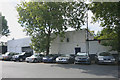
2
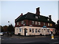
Prince of Wales, Public House, Camberwell
At the roundabout junction of Knatchbull Road (on the left) and Denmark Road (on the right).
Image: © David Anstiss
Taken: 2 Oct 2011
0.05 miles
3
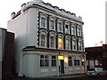
115 Denmark Hill, Camberwell
Beside the railway arches of the Loughborough Junction to Queen's Road, Peckham, Railway line (on the right).
May have been a former pub, but cannot find any reference to any.
Now flats.
Image: © David Anstiss
Taken: 2 Oct 2011
0.06 miles
4
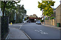
Northwest on Denmark Road, Camberwell, London
The turning to the left is Carew Street. The railway bridge carries the Thameslink route from Blackfriars (right) south towards Loughborough Junction (left).
Image: © Robin Stott
Taken: 17 Sep 2015
0.06 miles
5
Camberwell station frontage
Camberwell was once a station on the City branch of the London Chatham & Dover Railway whose line still runs into London (Blackfriars) and beyond. Camberwell opened in 1862 but closed to passengers in 1916 as a wartime economy. By that time much of its traffic had been syphoned off by competing tramways and it did not reopen.
Image: © David Kemp
Taken: 16 Aug 2014
0.07 miles
6
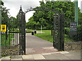
Gates, eastern entrance to Myatt's Fields Park
Behind the camera is the five-way junction of Calais Street, Flodden Road, Knatchbull Road and Denmark Road SE5.
Image: © Robin Stott
Taken: 23 Jun 2013
0.07 miles
7
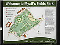
Myatt's Fields Park welcome sign
The text on the right forms the shared description below.
Image: © Robin Stott
Taken: 23 Jun 2013
0.07 miles
8
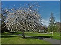
Springtime in Myatt's Fields Park, Camberwell
Myatt's Fields Park is named after Joseph Myatt, a tenant market gardener who grew rhubarb, strawberries and cabbages here in the nineteenth century. The land was donated for use as a public park from the estate of the Minet family, and was first opened to the public in 1889.
Image: © Neil Theasby
Taken: 1 May 2016
0.09 miles
9
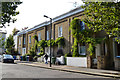
Older terrace houses, Warner Road, Camberwell, London
They have a Regency feel. An OS town plan of 1850 seems to show this terrace. Warner Road was then called Londonderry Road. The ornate cast iron windowbox guards feature a V Image Perhaps the houses date from Victoria's accession.
Image: © Robin Stott
Taken: 17 Sep 2015
0.09 miles
10
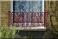
Cast iron windowbox guard, terraced houses, Warner Road, Camberwell, London
There could be an ornate V in the design: might it stand for Victoria? The houses are seen in Image
Image: © Robin Stott
Taken: 17 Sep 2015
0.09 miles