IMAGES TAKEN NEAR TO
Bengeworth Road, LONDON, SE5 9AJ
Introduction
This page details the photographs taken nearby to Bengeworth Road, SE5 9AJ by members of the Geograph project.
The Geograph project started in 2005 with the aim of publishing, organising and preserving representative images for every square kilometre of Great Britain, Ireland and the Isle of Man.

There are currently over 7.5m images from over14,400 individuals and you can help contribute to the project by visiting https://www.geograph.org.uk
Image Map
Images are licensed for reuse under creativecommons.org/licenses/by-sa/2.0
Notes
- Clicking on the map will re-center to the selected point.
- The higher the marker number, the further away the image location is from the centre of the postcode.
Image Listing (104 Images Found)
Images are licensed for reuse under creativecommons.org/licenses/by-sa/2.0
Image
Details
Distance
2
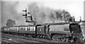
Down Continental Boat express at Cambria Road Junction, near Denmark Hill
View westward from near Ruskin Park, towards Brixton and Victoria. The train is running from Victoria via the Catford Loop rather than the usual (ex-London, Chatham & Dover) route via Sydenham Hill. The locomotive is SR Bulleid Light Pacific No. 34101 'Hartland' (built 2/50, subsequently rebuilt 9/60, withdrawn 7/66 but preserved and now on the North Yorkshire Moors Railway). Cambria Road Junction Box is visible behind the train, controlling the loop off the Holborn Viaduct line at Loughborough Junction.
Image: © Ben Brooksbank
Taken: 22 Apr 1953
0.08 miles
3
Bessemer Road Car Park
Car parking for staff, patients and visitors to King's College Hospital is very fraught. This car park is expensive but if you leave your vehicle on the road you are very likely to be ticketed. Picture taken in 2000 shows hospital building on the right with cranes working on the new block.
Image: © David Wright
Taken: 24 Sep 2000
0.11 miles
4
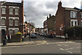
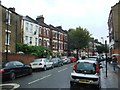
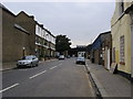
Northlands Street, Camberwell, south London
One of several parallel streets off Coldharbour Lane. The view is southeast.
Image: © Robin Stott
Taken: 20 Feb 2017
0.12 miles
5
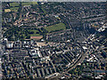
Brixton from the air
King's College Hospital is on the left, Loughborough railway junction and station are on the right.
Image: © Thomas Nugent
Taken: 22 Jun 2015
0.13 miles
8
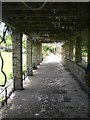
Foliage-covered walkway, Ruskin Park SE5
Image: © Robin Sones
Taken: 19 May 2009
0.13 miles
9
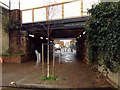
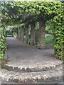
"Today is Your Day"
Walkway under the railway that splits Cambria Road in half.
Image: © Neil Theasby
Taken: 24 Jan 2016
0.14 miles
10
Padfield road
Padfield road leading up to the railway bridge
Image: © Shaun Ferguson
Taken: 18 Sep 2008
0.14 miles