IMAGES TAKEN NEAR TO
Evesham Walk, LONDON, SE5 8SJ
Introduction
This page details the photographs taken nearby to Evesham Walk, SE5 8SJ by members of the Geograph project.
The Geograph project started in 2005 with the aim of publishing, organising and preserving representative images for every square kilometre of Great Britain, Ireland and the Isle of Man.

There are currently over 7.5m images from over14,400 individuals and you can help contribute to the project by visiting https://www.geograph.org.uk
Image Map (Loading...)


Getting Data...Please wait
Leaflet Map data © OpenStreetMap
Images are licensed for reuse under creativecommons.org/licenses/by-sa/2.0
Notes
- Clicking on the map will re-center to the selected point.
- The higher the marker number, the further away the image location is from the centre of the postcode.
Image Listing (296 Images Found)
Images are licensed for reuse under creativecommons.org/licenses/by-sa/2.0
Image
Details
Distance
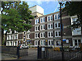
1
Allendale Close, Camberwell, south London
This low-rise residential development from the 1980s is an oasis of relative quiet just a few steps from busy Denmark Hill and Camberwell Church Street. It's possible that many people who live here work at King's College Hospital or the Maudsley, which occupy a considerable area to the south. I say relative because there is no escape from the Camberwell soundscape – ambulance sirens, and jets approaching Heathrow: a dissonant whine swelling to a roar every two minutes at peak hours.
Old maps from the late 19th century show streets of terraced houses. Allendale Road is one of the streetnames; another is Selborne Road, now a stub off Denmark Hill. In Love Walk there is a stone inscribed 'Selborne', so the development may at first have been known as the Selborne Estate. Cuthill and Kerfield are other streetname elements retained.
Image: © Robin Stott
Taken: 29 Aug 2016
0.02 miles
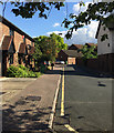
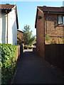
2
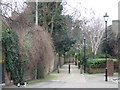
Evesham Walk off Love Walk, north side, Camberwell
Image: © Robin Stott
Taken: 4 Aug 2013
0.02 miles
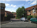
3
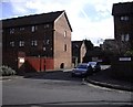
North side of Allendale Close, Camberwell
Allendale Close is a pleasant low-rise estate of flats and houses tucked in behind Denmark Hill. There are footpath connections to Love Walk.
Image: © Robin Stott
Taken: 26 Aug 2013
0.04 miles
4
Jennie Lee House, Love Walk, Camberwell
Jennie Lee was a minister in a Labour government.
Image: © Robin Stott
Taken: 4 Aug 2013
0.05 miles
5
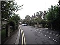
Love Walk, SE5
Footpath leading through to Denmark Hill.
Image: © Malc McDonald
Taken: 13 Mar 2010
0.05 miles
6
Love Walk Camberwell
Taken looking toward Grove Lane
Image: © PAUL FARMER
Taken: 20 Sep 2009
0.05 miles
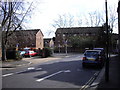
7
Allendale Close
Picture taken from Daneville Road
Image: © PAUL FARMER
Taken: 7 Mar 2009
0.06 miles
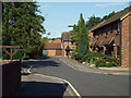
8
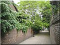
Hascombe Terrace, Camberwell
This pleasant footpath is the continuation of Love Walk. The turn into Allendale Close is on the left. Seen on a cloudy-bright Sunday morning in June.
Image: © Robin Stott
Taken: 22 Jun 2013
0.06 miles
9
Footpath from Daneville Road into Allendale Close, Camberwell
Allendale Close is a pleasant low-rise estate of flats and houses tucked in behind Denmark Hill. There are footpath connections to Love Walk.
Image: © Robin Stott
Taken: 26 Aug 2013
0.06 miles
10
Orpheus Street
Picture is taken looking toward Daneville Road
Image: © PAUL FARMER
Taken: 7 Mar 2009
0.06 miles