IMAGES TAKEN NEAR TO
Peckham Road, LONDON, SE5 8GB
Introduction
This page details the photographs taken nearby to Peckham Road, SE5 8GB by members of the Geograph project.
The Geograph project started in 2005 with the aim of publishing, organising and preserving representative images for every square kilometre of Great Britain, Ireland and the Isle of Man.

There are currently over 7.5m images from over14,400 individuals and you can help contribute to the project by visiting https://www.geograph.org.uk
Image Map
Images are licensed for reuse under creativecommons.org/licenses/by-sa/2.0
Notes
- Clicking on the map will re-center to the selected point.
- The higher the marker number, the further away the image location is from the centre of the postcode.
Image Listing (152 Images Found)
Images are licensed for reuse under creativecommons.org/licenses/by-sa/2.0
Image
Details
Distance
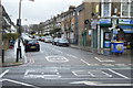
4

Total Petrol Station Peckham Road London
Image: © PAUL FARMER
Taken: 28 Oct 2012
0.03 miles
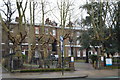
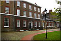
5
Camberwell College of Arts
Affiliated to the University of Arts, London.
Image: © Chris Whippet
Taken: 21 Feb 2015
0.03 miles
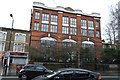
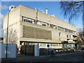
6
Former Camberwell House asylum, now part of the University of the Arts
Image: © Christopher Hilton
Taken: 7 Oct 2015
0.03 miles
7
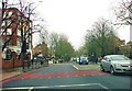
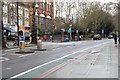
Peckham Road, SE5
Where the 2 yellow box junctions are, on the left is the town hall of the London Borough of Southwark on the corner of Havil Street, on the right is Vestry Road.
Image: © Phillip Perry
Taken: 26 Nov 2008
0.03 miles
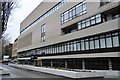
9
Former Camberwell House asylum, now part of the University of the Arts
Image: © Christopher Hilton
Taken: 7 Oct 2015
0.04 miles