IMAGES TAKEN NEAR TO
Gylcote Close, LONDON, SE5 8EU
Introduction
This page details the photographs taken nearby to Gylcote Close, SE5 8EU by members of the Geograph project.
The Geograph project started in 2005 with the aim of publishing, organising and preserving representative images for every square kilometre of Great Britain, Ireland and the Isle of Man.

There are currently over 7.5m images from over14,400 individuals and you can help contribute to the project by visiting https://www.geograph.org.uk
Image Map
Images are licensed for reuse under creativecommons.org/licenses/by-sa/2.0
Notes
- Clicking on the map will re-center to the selected point.
- The higher the marker number, the further away the image location is from the centre of the postcode.
Image Listing (69 Images Found)
Images are licensed for reuse under creativecommons.org/licenses/by-sa/2.0
Image
Details
Distance
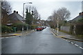
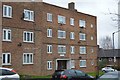
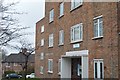
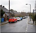
7
Houses on Sunray Avenue, SE24
These houses were built in the 1920s for the Borough of Camberwell. The local authorities were later reorganised into larger boroughs. This area is now part of the London Borough of Southwark.
Image: © Malc McDonald
Taken: 17 Oct 2010
0.09 miles
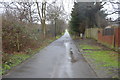
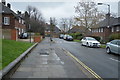
9
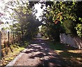
Greendale, Denmark Hill
This footpath and cyclepath leads from Blanchedowne (road - Denmark Hill), down towards East Dulwich Road.
Also used by National Cycle Route 23
Image: © David Anstiss
Taken: 2 Oct 2011
0.10 miles