IMAGES TAKEN NEAR TO
Basingdon Way, LONDON, SE5 8ER
Introduction
This page details the photographs taken nearby to Basingdon Way, SE5 8ER by members of the Geograph project.
The Geograph project started in 2005 with the aim of publishing, organising and preserving representative images for every square kilometre of Great Britain, Ireland and the Isle of Man.

There are currently over 7.5m images from over14,400 individuals and you can help contribute to the project by visiting https://www.geograph.org.uk
Image Map
Images are licensed for reuse under creativecommons.org/licenses/by-sa/2.0
Notes
- Clicking on the map will re-center to the selected point.
- The higher the marker number, the further away the image location is from the centre of the postcode.
Image Listing (61 Images Found)
Images are licensed for reuse under creativecommons.org/licenses/by-sa/2.0
Image
Details
Distance
3
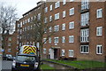
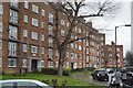
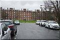
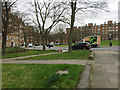
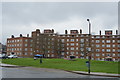
Basingdon Way, East Dulwich
This large roundabout / garden/ play area is surrounded by three large blocks of housing. Tayside Court (is behind the viewer). Bekesbourne Court is on the left and Perth Court is on the right.
Image: © David Anstiss
Taken: 2 Oct 2011
0.03 miles
5
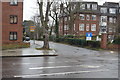
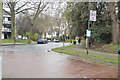
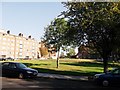
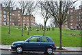
Basingdon Way, Denmark Hill Estate, Camberwell, south London
The road runs in a circle around a green, with flats on three sides: monumental.
Image: © Robin Stott
Taken: 21 Feb 2017
0.04 miles
7
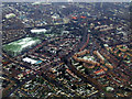
Dulwich from the air
Viewed from a London City bound flight from Glasgow.
Image: © Thomas Nugent
Taken: 6 Feb 2012
0.05 miles