IMAGES TAKEN NEAR TO
Harris Street, LONDON, SE5 7SA
Introduction
This page details the photographs taken nearby to Harris Street, SE5 7SA by members of the Geograph project.
The Geograph project started in 2005 with the aim of publishing, organising and preserving representative images for every square kilometre of Great Britain, Ireland and the Isle of Man.

There are currently over 7.5m images from over14,400 individuals and you can help contribute to the project by visiting https://www.geograph.org.uk
Image Map
Images are licensed for reuse under creativecommons.org/licenses/by-sa/2.0
Notes
- Clicking on the map will re-center to the selected point.
- The higher the marker number, the further away the image location is from the centre of the postcode.
Image Listing (72 Images Found)
Images are licensed for reuse under creativecommons.org/licenses/by-sa/2.0
Image
Details
Distance
1
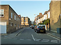
Elmington Road SE5
Looking from the Ada Road end along the short leg of the L-shaped road.
Image: © Robin Webster
Taken: 19 Nov 2011
0.04 miles
2
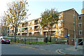
Flats, Owgan Close, SE5
Looking from Elmington Road.
Image: © Robin Webster
Taken: 19 Nov 2011
0.06 miles
3
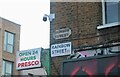
Old and new signs for Rainbow Street, Camberwell
Image: © David Howard
Taken: 27 Mar 2022
0.06 miles
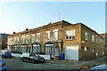
4
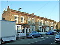
1 - 9 (odds) Ada Road, SE5
Late Victorian houses with a more recent extension at the far end.
Image: © Robin Webster
Taken: 19 Nov 2011
0.06 miles
5
1 - 9 (odds) Ada Road, SE5
Late Victorian houses with a more recent extension this end.
Image: © Robin Webster
Taken: 19 Nov 2011
0.06 miles
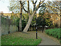
6

Welcome to Brunswick Park
A small park with two tennis courts, a basketball/kickabout area and a small children's play apparatus area, the last just beyond the hedge.
Image: © Robin Webster
Taken: 19 Nov 2011
0.08 miles
7
A corner of Brunswick Park
A small park with a playground just to the right of the hedge.
Image: © Robin Webster
Taken: 19 Nov 2011
0.09 miles
8
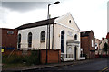
Southwark: Cottage Green Chapel
Now a day nursery
Image: © Dr Neil Clifton
Taken: 5 Jul 2012
0.09 miles
9
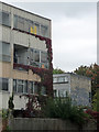
Elmington Estate, Benhill Road
Put up by the London County Council in 1948-58, presumably when funds were short as much of it is clad in metal panels, concealing Lord knows what. Although there is some evidence of occupation, many flats are boarded up and most cannot be long for this world.
Image: © Stephen Richards
Taken: 17 Oct 2015
0.09 miles
10
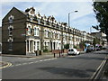
Peckham, terraced houses
A well-maintained terrace on Southampton Way, at the junction with Bonsor Street.
Image: © Mike Faherty
Taken: 16 Aug 2009
0.10 miles