IMAGES TAKEN NEAR TO
Hopewell Street, LONDON, SE5 7QS
Introduction
This page details the photographs taken nearby to Hopewell Street, SE5 7QS by members of the Geograph project.
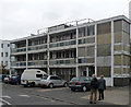
The Geograph project started in 2005 with the aim of publishing, organising and preserving representative images for every square kilometre of Great Britain, Ireland and the Isle of Man.

There are currently over 7.5m images from over14,400 individuals and you can help contribute to the project by visiting https://www.geograph.org.uk
Image Map
Images are licensed for reuse under creativecommons.org/licenses/by-sa/2.0
Notes
- Clicking on the map will re-center to the selected point.
- The higher the marker number, the further away the image location is from the centre of the postcode.
Image Listing (154 Images Found)
Images are licensed for reuse under creativecommons.org/licenses/by-sa/2.0
Image
Details
Distance
1
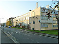
Flats on Houseman Way, SE5
The road is actually Elmington Road, but this is the back of the flats, accessed from the other side.
Image: © Robin Webster
Taken: 19 Nov 2011
0.04 miles
2
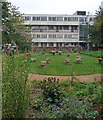
Nature garden, Benhill Road
Created, or spruced up, by the Froglife charity in 2013 as part of the London Dragon Finder Project, although there has been a garden here since the early 1980s.
Beyond are some of the tired blocks of the 1950s Elmington Estate.
Image: © Stephen Richards
Taken: 17 Oct 2015
0.05 miles
3
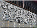
Mural, Benhill Road
Inspired by the Pied Piper of Hamlyn. Made in concrete, granite and pebbles, by Willi Soukop, 1959, originally placed on an Elmington Estate community centre, since demolished, and re-sited on the side of a new sports hall.
Image: © Stephen Richards
Taken: 17 Oct 2015
0.06 miles
4
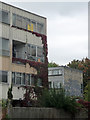
Elmington Estate, Benhill Road
Put up by the London County Council in 1948-58, presumably when funds were short as much of it is clad in metal panels, concealing Lord knows what. Although there is some evidence of occupation, many flats are boarded up and most cannot be long for this world.
Image: © Stephen Richards
Taken: 17 Oct 2015
0.06 miles
5
90-106 Benhill Road
One of the low-rise blocks of the Elmington Estate, put by the London County Council in 1948-58. Much of it now looks very tired and presumably is not long for this world.
Image: © Stephen Richards
Taken: 17 Oct 2015
0.07 miles
6
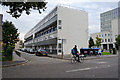
Drayton House, off Lomond Grove, Camberwell
The accommodation appears to be maisonettes that run the full depth of the building, two high. This is the front; the rear faces Elmington Road: Image
Image: © Robin Stott
Taken: 18 Sep 2015
0.11 miles
7
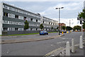
East on Elmington Road, Camberwell
Drayton House, the long terrace, looks as though it may be maisonettes, not flats. This is the rear; the front is seen in Image
Image: © Robin Stott
Taken: 18 Sep 2015
0.11 miles
8
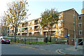
Flats, Owgan Close, SE5
Looking from Elmington Road.
Image: © Robin Webster
Taken: 19 Nov 2011
0.11 miles
9
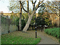
A corner of Brunswick Park
A small park with a playground just to the right of the hedge.
Image: © Robin Webster
Taken: 19 Nov 2011
0.11 miles
10
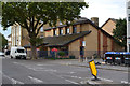
Salvation Army Community Church, Lomond Grove, Camberwell
There appears to be a hostel behind the church, opposite Drayton House on an unnamed cul-de-sac.
Image: © Robin Stott
Taken: 18 Sep 2015
0.11 miles