IMAGES TAKEN NEAR TO
Wodehouse Avenue, LONDON, SE5 7FB
Introduction
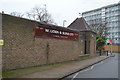
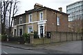
This page details the photographs taken nearby to Wodehouse Avenue, SE5 7FB by members of the Geograph project.
The Geograph project started in 2005 with the aim of publishing, organising and preserving representative images for every square kilometre of Great Britain, Ireland and the Isle of Man.

There are currently over 7.5m images from over14,400 individuals and you can help contribute to the project by visiting https://www.geograph.org.uk
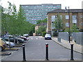
Image Map
Images are licensed for reuse under creativecommons.org/licenses/by-sa/2.0
Notes
- Clicking on the map will re-center to the selected point.
- The higher the marker number, the further away the image location is from the centre of the postcode.
Image Listing (122 Images Found)
Images are licensed for reuse under creativecommons.org/licenses/by-sa/2.0
Image
Details
Distance
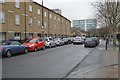
1
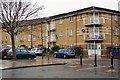
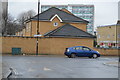
Peckham regeneration
New housing in Peckham, with a tower block from Camberwell's Sceaux Gardens Estate looming in the background.
Image: © Malc McDonald
Taken: 3 May 2010
0.03 miles
8
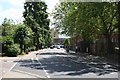
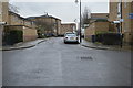
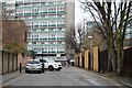
Peckham: Southampton Way
Looking south at the south end of Southampton Way, towards its junction with Peckham Road. Oliver Goldsmith school is on the right.
Image: © Dr Neil Clifton
Taken: 5 Jul 2012
0.05 miles