IMAGES TAKEN NEAR TO
New Church Road, LONDON, SE5 7FA
Introduction
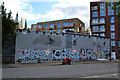
This page details the photographs taken nearby to New Church Road, SE5 7FA by members of the Geograph project.
The Geograph project started in 2005 with the aim of publishing, organising and preserving representative images for every square kilometre of Great Britain, Ireland and the Isle of Man.

There are currently over 7.5m images from over14,400 individuals and you can help contribute to the project by visiting https://www.geograph.org.uk
Image Map
Images are licensed for reuse under creativecommons.org/licenses/by-sa/2.0
Notes
- Clicking on the map will re-center to the selected point.
- The higher the marker number, the further away the image location is from the centre of the postcode.
Image Listing (165 Images Found)
Images are licensed for reuse under creativecommons.org/licenses/by-sa/2.0
Image
Details
Distance
1
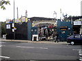
Architectural Rescue Yard, Southampton Way, Peckham
Image: © PAUL FARMER
Taken: 9 Jul 2011
0.01 miles
2
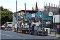
Second-hand emporium, Southampton Way, Camberwell
Image: © Robin Stott
Taken: 19 Sep 2015
0.01 miles
3
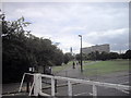
Burgess Park, Peckham with the Shard in the distance
Image: © PAUL FARMER
Taken: 9 Jul 2011
0.01 miles
4
Entrance to second-hand emporium, Southampton Way, Camberwell
There's been a change of name since Paul Farmer's 2011 view: Image
Image: © Robin Stott
Taken: 19 Sep 2015
0.02 miles
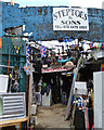
5
Side of Steptoes and Sons, New Church Road, Camberwell
The frontage of this second-hand emporium, and some of the goods, is at the north end of Southampton Way. The view is from the southwest edge of Burgess Park. A nearby plaque, part of the Bridge to Nowhere Burgess Park Heritage Trail, explains that New Church Road was originally laid out as an elegant approach to the new St George's Church on Wells Way Image In the background, newly-built flats by Edmund Street.
Image: © Robin Stott
Taken: 19 Sep 2015
0.02 miles
6
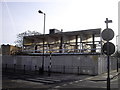
Derelict flats in New Church Road Camberwell
Image: © PAUL FARMER
Taken: 31 Jan 2010
0.02 miles
7
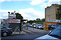
Car servicing business, Southampton Row, Camberwell
Image: © Robin Stott
Taken: 19 Sep 2015
0.03 miles
8
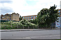
Vacant site with tree, New Church Road, Camberwell, overrun with Russian Vine
Russian Vine or Mile-a-Minute is Fallopia baldschuanica, formerly Polygonum baldschuanicum. It is offered as a plant for covering unsightly structures but it can be invasive, as here.
Image: © Robin Stott
Taken: 19 Sep 2015
0.03 miles
9
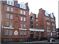
Evelina Mansions New Church Road Camberwell
The Industrial Dwellings Company Ltd built this block.
Image: © PAUL FARMER
Taken: 31 Jan 2010
0.04 miles
10
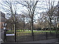
Addington Square Camberwell
The square is named after Henry Addington, Prime Minister from 1801 to 1804.
Image: © PAUL FARMER
Taken: 31 Jan 2010
0.04 miles