IMAGES TAKEN NEAR TO
Southampton Way, LONDON, SE5 7EQ
Introduction
This page details the photographs taken nearby to Southampton Way, SE5 7EQ by members of the Geograph project.
The Geograph project started in 2005 with the aim of publishing, organising and preserving representative images for every square kilometre of Great Britain, Ireland and the Isle of Man.

There are currently over 7.5m images from over14,400 individuals and you can help contribute to the project by visiting https://www.geograph.org.uk
Image Map
Images are licensed for reuse under creativecommons.org/licenses/by-sa/2.0
Notes
- Clicking on the map will re-center to the selected point.
- The higher the marker number, the further away the image location is from the centre of the postcode.
Image Listing (131 Images Found)
Images are licensed for reuse under creativecommons.org/licenses/by-sa/2.0
Image
Details
Distance
1
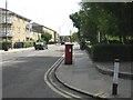
Camberwell, postbox
Victorian postbox on Southampton Way, ID SE5 52.
Image: © Mike Faherty
Taken: 16 Aug 2009
0.05 miles
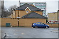
5
St Luke, Pentridge Street, London SE15 - Church Hall
Image: © John Salmon
Taken: 21 Feb 2010
0.06 miles
8
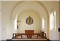
St Luke, Pentridge Street, London SE15 - Lady chapel
Image: © John Salmon
Taken: 21 Feb 2010
0.07 miles
9

St Luke, Pentridge Street, London SE15 - Statue
St Luke
Image: © John Salmon
Taken: 21 Feb 2010
0.07 miles